
Lost in longitude or confused by contour lines? Want to know all the tips and tricks for getting the most out of your atlas? Curious if paper towns still exist? "Ask a Cartographer" is your opportunity to get the facts straight from the source. Tom Vitacco, Rand McNally Publishing’s Director of GIS is here to answer your burning questions, and geek out over fascinating map lore – one exploration at a time.
This week, we're talking about the use of AI when creating maps.
Question: AI is very popular these days. Do you use AI to make maps?
Tom’s answer: Interesting question and I agree that AI is extremely popular today. The quick answer to your question is no, we do not use AI to make maps at Rand McNally Publishing. Also, in case you were wondering, I did not use AI to write this answer either! In fact, I have never used AI for anything other than to dabble with some art and graphics since the Adobe Creative Cloud Suite we use as part of our map production offers Generative AI tools.
AI Tools for GIS
Before I talk about why we don’t use AI tools in our specific GIS and mapping workflows, I wanted to acknowledge that AI has been used in our industry for years and I am positive AI will continue to be very influential on GIS and cartography in the future. If you work in the field, you probably have already heard about tools or websites such as GeoAI, CartoAI, MapsGPT, Better Maps, or Proxi Maps. In theory, these tools help automate GIS-related tasks such as feature extraction, change detection, image analysis, environmental monitoring, and quality control. Some of the websites claim to produce interactive maps using AI tools which can be printed or linked to your own website. Plus, GIS software now includes AI plugins which incorporate artificial intelligence into the tools you currently use.

For example, suppose you have a scenario where you must identify buildings, roads and crop land from an aerial image. You could use a “trained” AI tool or model to extract the features you need in one quick process compared to the time it might take a “trained” GIS analyst to complete. Another example would be an AI algorithm that analyzes large amounts of data to identify patterns, inconsistencies, or discrepancies…even potential map errors. The implications are endless, and I have no doubt AI tools will become the norm in the GIS industry.
AI Tools for Cartography
While the future of AI within the GIS industry is exciting, I believe AI still has a lot to learn in terms of cartography and producing maps similar to the ones found in our Road Atlas products. As I mentioned, we do not use AI tools or processes, at least for now, in our cartographic workflows mainly because we do not perform the types of processes that AI excels at when we create Road Atlas-style maps.
To produce Rand McNally Publishing maps, we use databases built from scratch by trained cartographers, geographers, and GIS technicians, who spent a lot of time compiling and manipulating map data with one goal in mind—to produce high-quality printed state maps which our customers rely on for trip planning and navigation. Currently, we do not analyze large amounts of satellite imagery for data patterns or feature extraction, nor do we run AI processes to check the quality of our map data because our data is already very high quality and was checked when we constructed the databases.
Of course, if we decide to build new atlases or products that require image tracing or data extraction, then AI might have a prominent role in our daily workflows. Plus, AI might be able to assist with our research processes especially related to new road construction, but at this point I do not believe AI will dominate the “cartographic” side of our field any time soon. In my humble opinion, map design, creativity, and decision making for cartographic-focused products will still require a human touch to create functional map databases and visually appealing printed maps.
Cartography Experiments with AI Tools
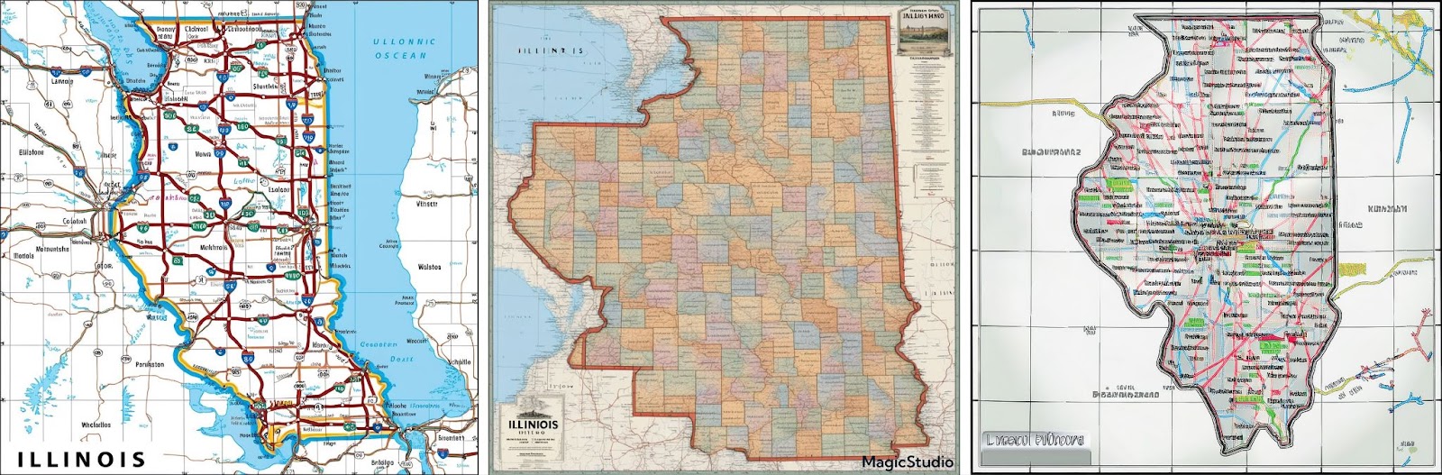
Recently, I ran a few experiments with AI mapping tools and websites and the results were cool, but not anywhere close to a road atlas-style map. The images below were created by typing “create a road atlas-style map of Illinois” or something along those lines into generative AI apps. The image on the left was created in Leonardo.ai, the image in the center was from Magic Studio and the image on the right was produced within the Adobe Creative Cloud Suite. While these attempts to create a map of Illinois might have an artistic appeal, the algorithm did not produce a true map of Illinois except for the basic shape of the state. Granted, these image creation apps were probably not created with mapping in mind, but I was curious to see what they would produce using a standard text prompt.
I also tried a couple of websites that claim to use AI to help you create web-based interactive maps or even printable maps if you subscribe to the site. The first one I tried (shown below) was built around Maputnik, an open-source style editor. Once I created a trial account, I typed the same prompt as above asking it to create a map of Illinois, which was confirmed by their AI assistant “Cass”, but the site never finished drawing a map and I bailed on it after hours of waiting. Eventually I tried to manually create a map on their site, but since the base map is OpenStreetMap, the map data was not suitable for a road atlas-style state map which we can create from our databases.

Next, I tried another site (see below) which is supposed to help you create interactive maps powered by AI. I played around with the site and while it might be useful for simple tour maps or an interactive map used by a local chamber of commerce, it is not set up to create road maps for print. There were a few other sites I found but did not test out because I felt they would produce similar results as the two I tested. If you are looking to create interactive web-based maps with some AI tools then any of these sites might be helpful but for high-quality, print-ready state maps like we produce, these AI powered mapping websites are not the right tool.

Thanks again for the question. AI is a powerful tool which is already being used in our industry, and I encourage you to play around with some of the cool apps and sites using AI with maps because they are fun and interesting. I hope I was able to offer some insight into how AI is used in the mapping field regardless of whether we are using it for our atlases or not.
Have a question for our cartographer? Email us at printproducts@randmcnally.com with “Ask a Cartographer” in the subject line and your question could be featured next.