
Lost in longitude or confused by contour lines? Want to know all the tips and tricks for getting the most out of your atlas? Curious if paper towns still exist? "Ask a Cartographer" is your opportunity to get the facts straight from the source. Tom Vitacco, Rand McNally Publishing’s Director of GIS is here to answer your burning questions, and geek out over fascinating map lore – one exploration at a time.
This week, we're discussing how Rand McNally can help you plan a road trip in your electric car.

Question: Can Rand McNally Publishing help me plan a road trip around charging stations for my electric vehicle?
Tom’s answer: Full disclosure…I do not own an electric vehicle so I don't have personal experience charging cars on a road trip. With that said, I will try to answer your question though and offer one example of how Rand McNally Publishing can help you plan a road trip with your electric vehicle.
Electric vehicles are becoming more and more popular. By the end of 2023, 3.3 million electric cars were on the road in the U.S. according to an
Experian Automotive Market Trends report. This is up from 2 million electric vehicles in 2022 and 1.3 million in 2021.
I read an article recently about how the percentage of charging stations has dramatically increased in the last decade as well. In 2021, the number of charging ports has grown by more than 55% according to the Department of Energy.
Electric Vehicles, Charging Stations, and Printed Maps
To answer your question, Rand McNally Publishing does not show any charging stations on our printed maps currently. We have discussed the idea a few different times during product planning meetings and the consensus has always been our map scales are not large enough to show all the stations around each state. While we might be able to show some stations on our more detailed city maps, the state maps would become too cluttered if we tried to add an icon for all the stations. A GPS or routing application on a device is a more appropriate medium to display charging stations since you can zoom in to a larger map scale compared to a printed map.
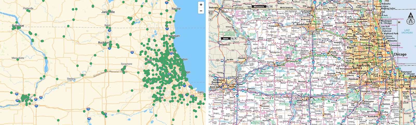
I tried to illustrate this point in the graphic above. The map on the left shows charging stations in northern Illinois from the U.S. Department of Energy interactive map. The charging stations are shown as green circles. The map on the right is a section of our current Road Atlas map of Illinois. Imagine trying to place all those green dots on a printed state map containing numerous labels, map icons and highway shields. While possible, the legibility would greatly suffer and most map content would need to be removed to show the stations.
However, our state maps display many helpful icons instead of charging stations, such as rest areas, waysides, ports of entry, visitor centers and even service areas in states such as New Jersey. Keep in mind there are fewer of these types of roadside facilities overall, so we can place them on our state maps without the need to remove other map content. If you have one of our atlases, please check the map legend for a full list of map symbols.
Trip Planning with an Electric Vehicle
Although we do not show charging stations on our maps, I believe we can still help! Rand McNally Publishing products are perfect for trip planning since they show you the “big picture” of your destination, so you could use one of our Road Atlases or State Maps in conjunction with an online map showing charging stations to map out the most best stops along your route.
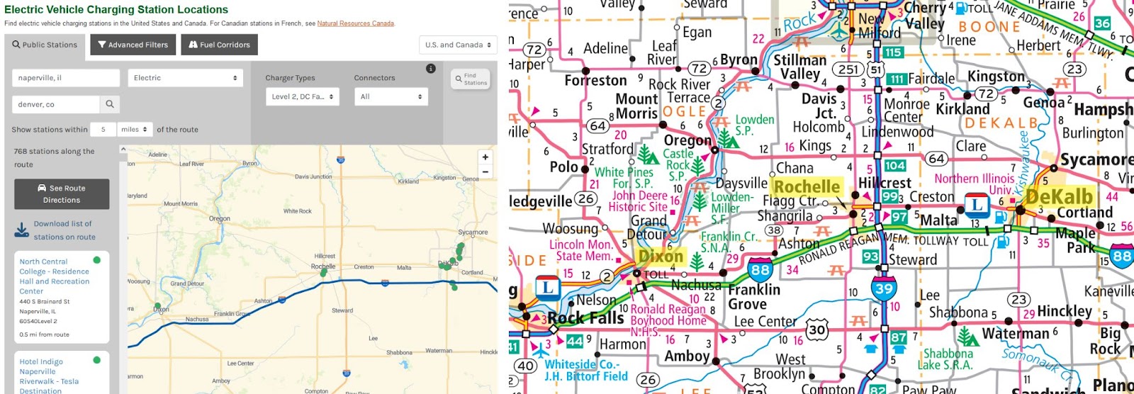
For example, say you are driving from Naperville, IL to Denver, CO in an EV and want to plan out the location of charging stations along the way before you leave on your trip. You could use an online map like the one on the Department of Energy site I mentioned earlier, run the route and have the application show stations within 5 miles of the route like shown on the left side of the image below. Since the Illinois towns of DeKalb, Rochelle and Dixon all have charging stations, you could highlight those towns in the atlas (right side of the image below), while also printing out the detailed locations from the website with the address and other information. The combination of the printed map and the online data could provide a good list of charging locations to include with other trip planning information you have collected.
Thanks again for the question! Feel free to submit your map or cartography questions below and check back next Tuesday for another installment of "Ask a Cartographer".
Have a question for our cartographer? Email us at printproducts@randmcnally.com with “Ask a Cartographer” in the subject line and your question could be featured next.