Lost in longitude or confused by contour lines? Want to know all the tips and tricks for getting the most out of your atlas? Curious if paper towns still exist? "Ask a Cartographer" is your opportunity to get the facts straight from the source. Tom Vitacco, Rand McNally Publishing’s Director of GIS is here to answer your burning questions, and geek out over fascinating map lore – one exploration at a time.
This week, we are discussing our atlases made for truckers and RVs in more detail than ever before…
Question: What is the difference between your regular Road Atlas and the Motor Carriers’ Road Atlas? If I drive an RV, should I buy the Motor Carriers’ Road Atlas?
Tom’s answer: Thank you for the great question! I have mentioned the Motor Carriers’ Road Atlas and that specific product line before in other posts, but have never taken the time to explain what makes the atlases different, so I will try to do that with this post. I do want to start by saying that the atlas was created for the trucking industry, not RVs specifically, but since RV and truck drivers face similar issues on the road, we feel the atlas is just as useful for the RV community as well.

For some additional background, Rand McNally has always offered products for the trucking industry throughout the entire 38 years of my cartographic career. The company today is now comprised of three individual units, including Rand McNally Fleet Solutions, which offers comprehensive fleet management and safety systems including software and hardware specifically geared towards the trucking industry, and MileMaker, developers of industry-leading mileage and routing software, providing consistent routes that save truckers time, money, and miles. Rand McNally Publishing, where I work, produces three different atlases with details to help truck drivers navigate the North American road network.

An Atlas for Truckers
To begin, it is important to mention something I discussed in a previous post about the base maps in our atlases. The state and city maps in the Road Atlas and the Motor Carriers’ Road Atlas are the same since we use one detailed map database for both sets of products. The map style is different, but the map content is the same.
What makes the Motor Carriers’ atlas different is we highlight the designated routes with STAA-authorized dimensions on the map using an orange ribbon, plus we show weigh stations with a red and black circle icon and large arrow to indicate their locations. STAA refers to the 1982 Surface Transportation Assistance Act, which identified concerns related to highway infrastructure and funding and established weight and size limits for trucks to help prevent early deterioration of highways.
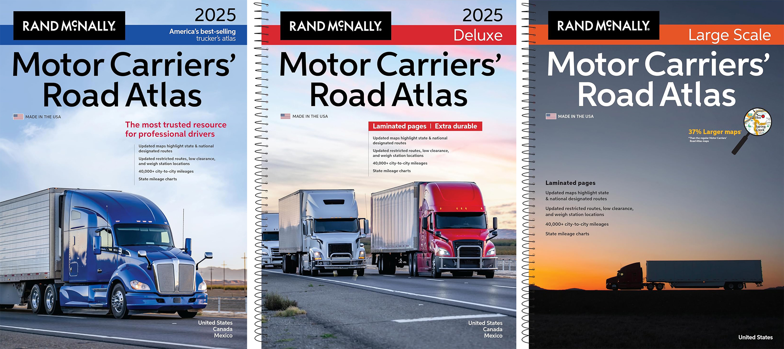
We currently produce three different atlases. The Motor Carriers’ Road Atlas is a paperback book with no lamination and our least expensive of the truck atlases, the Deluxe version which is laminated and uses a spiral binding so the pages lay flat, and the Large Scale version, similar to the Deluxe atlas but the maps are enlarged so it is easier to read. The laminated pages are more durable and allow for writing with suitable markers.

Pictured: The three different Motor Carriers’ atlases we currently produce.
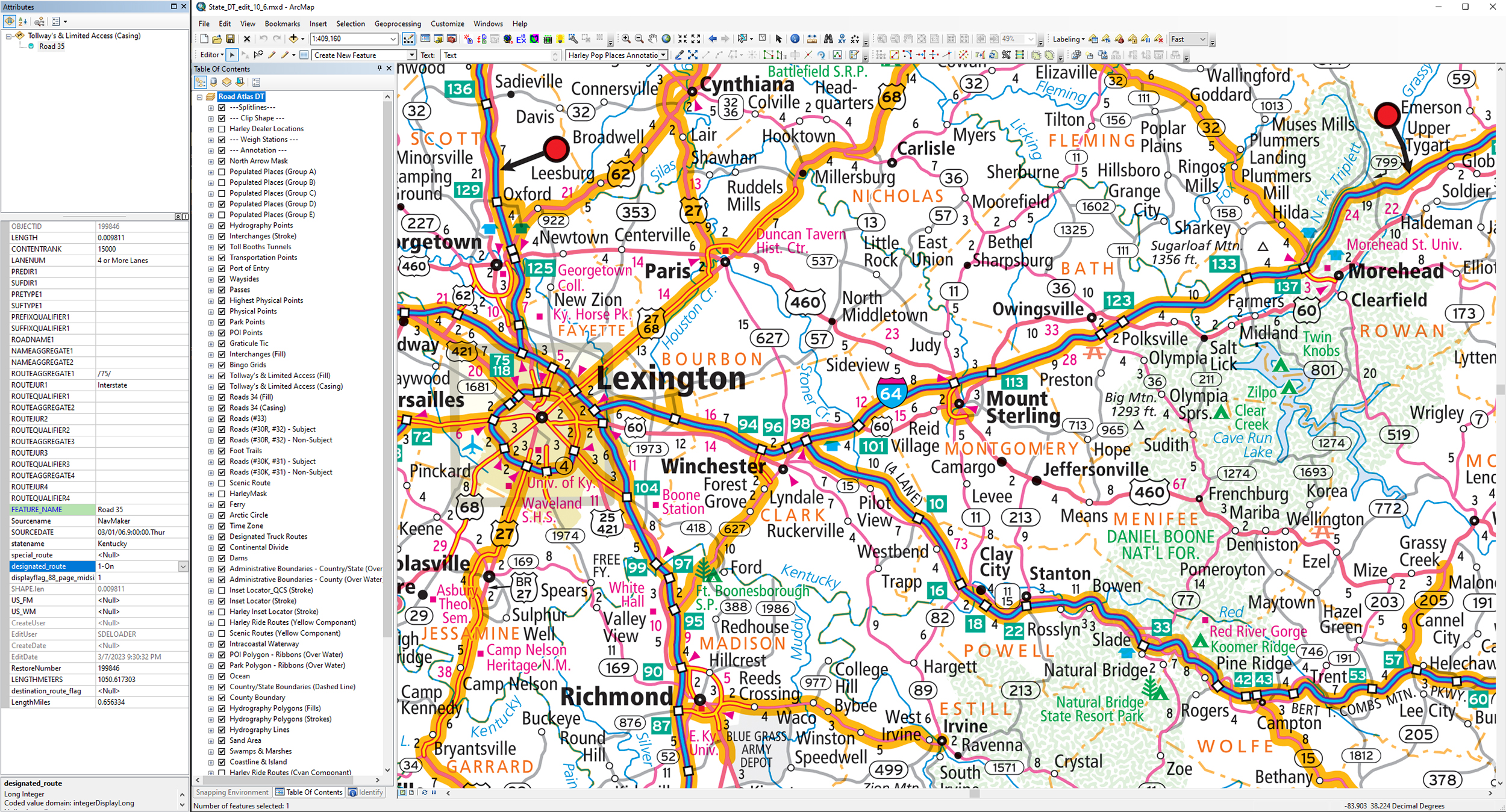
Since we maintain our map content within a database, we use attribution to indicate whether a road is a designated route. When we are ready to create the atlases, we export the maps using different templates which implement the appropriate map styles. For example, the image below depicts our map database and the map shown in central Kentucky is the same data which is displayed in the Road Atlas, the Motor Carriers’ and the State Easy to Fold product lines. When we produce the Motor Carriers’ atlas, the export template in this case includes the STAA routes and the weigh stations, so those features are included on the map because the layers are now active, and the road attribution data communicates that we should include the orange-colored ribbon under the roads.

Pictured: A section of Kentucky showing the truck-related attributes and data we include in our custom map database.
Map Data to Assist Truckers
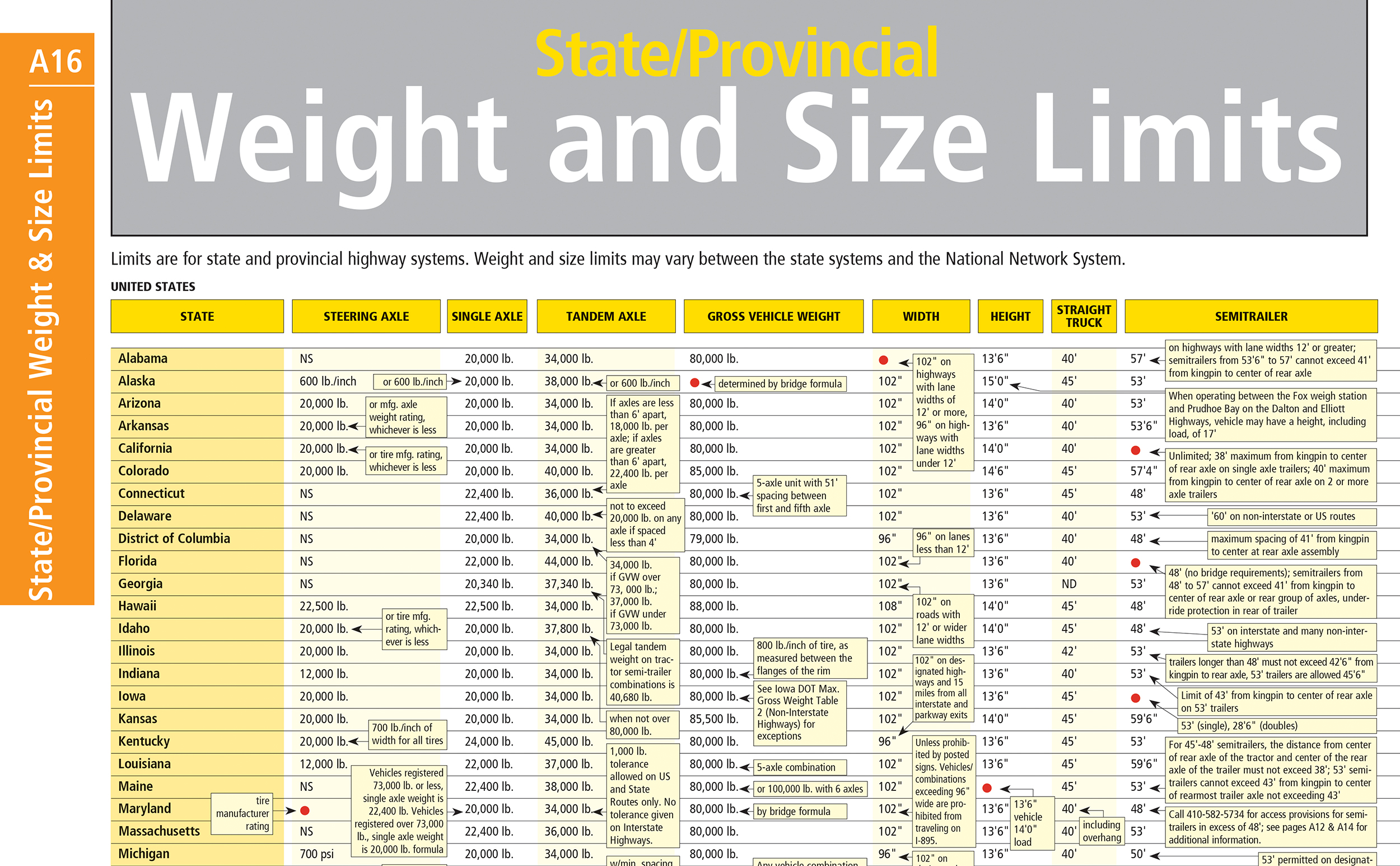
A lot of planning and research goes into obtaining truck-specific data from a variety of sources, including Departments of Transportation, city engineers, satellite imagery, and information provided by truckers who use our products. Besides the map style differences compared to the regular Road Atlas, the Motor Carriers’ atlas line includes a lot of informative tables, charts, and diagrams on top of the full section of maps, plus an index and mileage directory with more than 40,000 mileages between different cities. Some of the information includes weight and size limits for all states and Canadian provinces, as shown in the image below, which is researched and updated annually, and changes more often than you might think.

Pictured: A table containing weight and size limits by state from the 2025 Motor Carriers’ Road Atlas.
Additionally, we incorporate pages with data about low clearance locations, permanent weight stations with map references, and restricted routes as space permits for all the states and provinces (see image below for an example). There are also pages with information about border crossings, hazardous materials, fuel taxes, inspection procedures and even road conditions and hotel listings. Overall, the Motor Carriers’ Road Atlas product line includes comprehensive data that goes beyond just the map and designated routes which can be used by truckers and RVers while on the road.
Map Updates
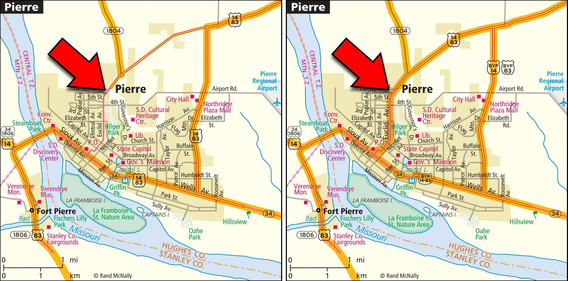
Finally, I wanted to provide a specific example of the types of changes or updates we might make to a map related to designated routes. The South Dakota Dept. of Transportation and the City of Pierre recently got approval to reroute US Highway 14/83 around the city because of a low clearance bridge near downtown. There has been a dramatic increase in the number of trucks hitting the bridge within the last decade, so we adjusted the map by removing the designated route ribbon from the roads through the city (as shown by the red arrows in the image below). The new version of the city map for the next edition of the atlas will show the designated route following the US 14/83 bypass, which is the new route suggested for trucks in this area. Although signs might not be posted along this route for a while, we will include this update because it was approved before our target date for inclusion in the next release of the atlas.

Pictured: The Pierre, SD city map to be included in the next edition Motor Carriers’ Road Atlas on the left with the designated route adjusted and the current version of the city map in print now on the right.
Thanks again for the interesting question! We have always supported the trucking industry by providing useful products that assist in fleet optimization, routing, and mileage calculations. These same products can be used by the RV community, and I hope I was able to explain in more detail why the Motor Carriers’ Road Atlas product line can be a valuable tool to guide you on your journey. The atlases are up to date, accurate and an excellent companion product to a GPS!
Feel free to submit your map or cartography questions below and check back next Tuesday for another installment of "Ask a Cartographer".
Have a question for our cartographer? Email us at printproducts@randmcnally.com with “Ask a Cartographer” in the subject line and your question could be featured next!


