
Lost in longitude or confused by contour lines? Want to know all the tips and tricks for getting the most out of your atlas? Curious if paper towns still exist? "Ask a Cartographer" is your opportunity to get the facts straight from the source. Tom Vitacco, Rand McNally Publishing’s Director of GIS is here to answer your burning questions, and geek out over fascinating map lore – one exploration at a time.
This week, we're discussing the most frequently asked questions we get about our products.
Question: What are some of the most frequently asked questions about your maps or products?
Tom’s answer: Thank you for the question about questions. We often get questions about our atlases, maps and products from customers, and do our best to answer any question in a timely manner. The easiest way to ask a question specifically about our maps is to send a message to printproducts@randmcnally.com, which is an email account monitored by the GIS team here at Rand McNally Publishing. There are other ways to contact the company, including the Contact Us page on our website or calling customer service, but the email above is the most direct way to ask a map related question or send feedback to the mapping team.
In terms of the most frequently asked questions about our maps or products, I will mention a few this week (Part One) and a few more next week (Part Two) and try to answer them as best I can. Honestly, you might be a bit surprised by the questions because they are probably not what you would expect and are often cartographic in nature.
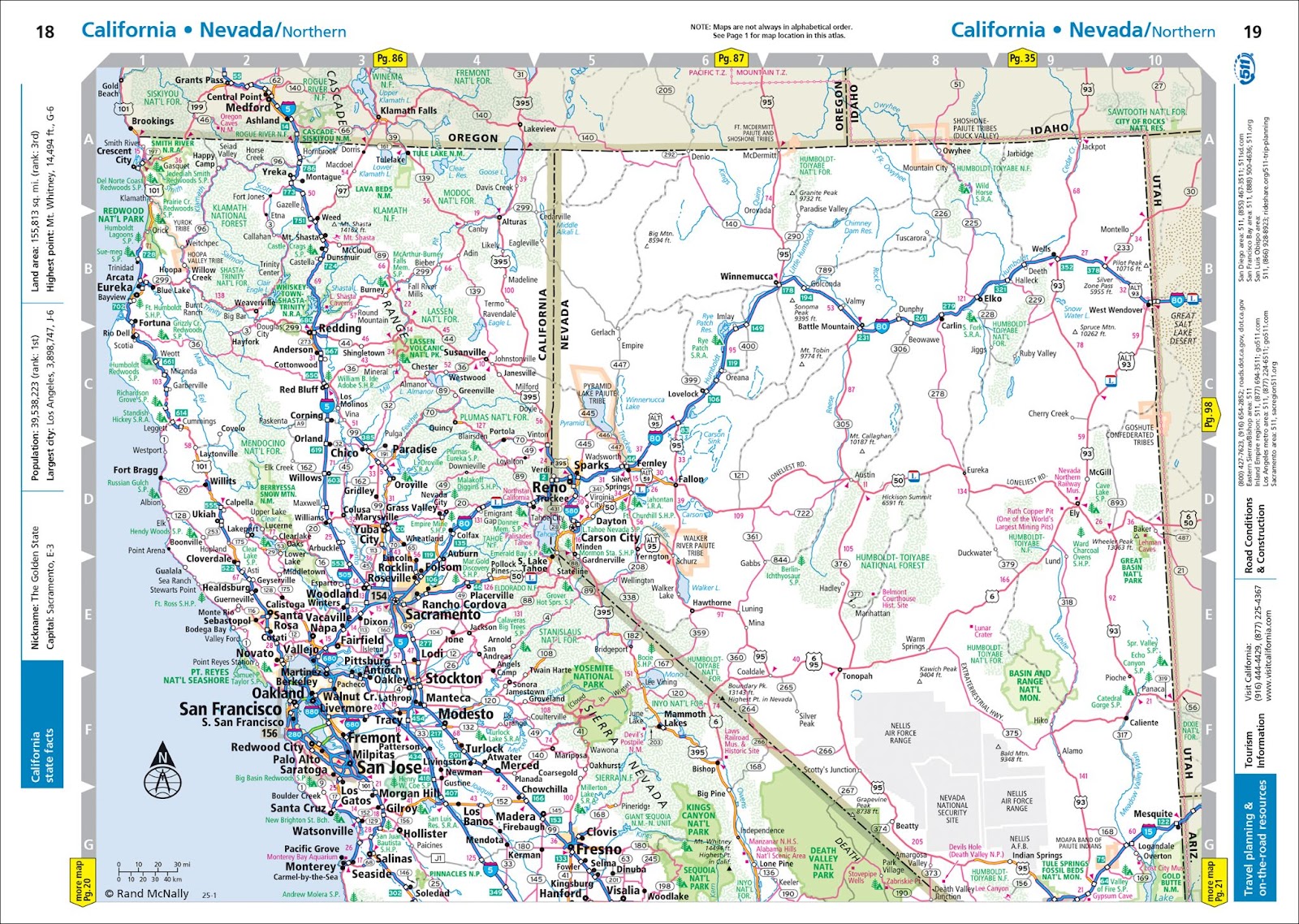
Pictured: Nevada combined with California in our Midsize Easy to Read Road Atlas.
Question 1: Why is Nevada missing from the Midsize Easy to Read Road Atlas?
Honestly, this is one of the questions we get asked the most. Nevada must be a popular state map in this specific product! To start, all states are included in the Midsize Easy to Read Road Atlas, but we do combine states in this particular atlas because the paper size is much smaller than our full-size Road Atlas and the Midsize atlas contains less pages overall. Therefore, we combine some state maps which are logical from a geographic standpoint.
So, California and Nevada are combined in this atlas, along with other states like Kentucky and Tennessee for example. The easiest way to find any map in our atlases is to use the Table of Contents at the front of the atlas. All states are listed with their associated page number so Nevada is listed with the same page number as California in this case. We always recommend customers use the table of contents as much as possible because it includes useful information for the specific product. We also post a note on top of every other page stating the maps are not always in alphabetical order and to refer to the table of contents for map locations in the atlas.
Question 2: Why is my hometown not shown on your map?
This question is asked quite often. We show a lot of content on our maps and as cartographers we strive to keep the maps clean and comprehensible while trying to balance the distribution of cities, highways, points of interest, parks, transportation and physical features and don’t forget the water like rivers and lakes. Cities are the most prominent feature along with roads, but there is just no way to show all cities and towns at the map scales we use in our products.
There are a few reasons your hometown might not be shown on our map. First, it depends on the product. The Midsize Easy to Read maps are much smaller scale and do not show as many cities, but most likely the city is shown in the regular Road Atlas or the state fold map. Also, near cities that include a large, detailed inset map, we often do not show towns on the state map when they are included on the city map instead. For example, in the image below, you will notice Ottawa Hills and Holland on the Toledo city map that are not shown on the main state map. So please check the city inset maps for towns if you do not see the city on the state map.
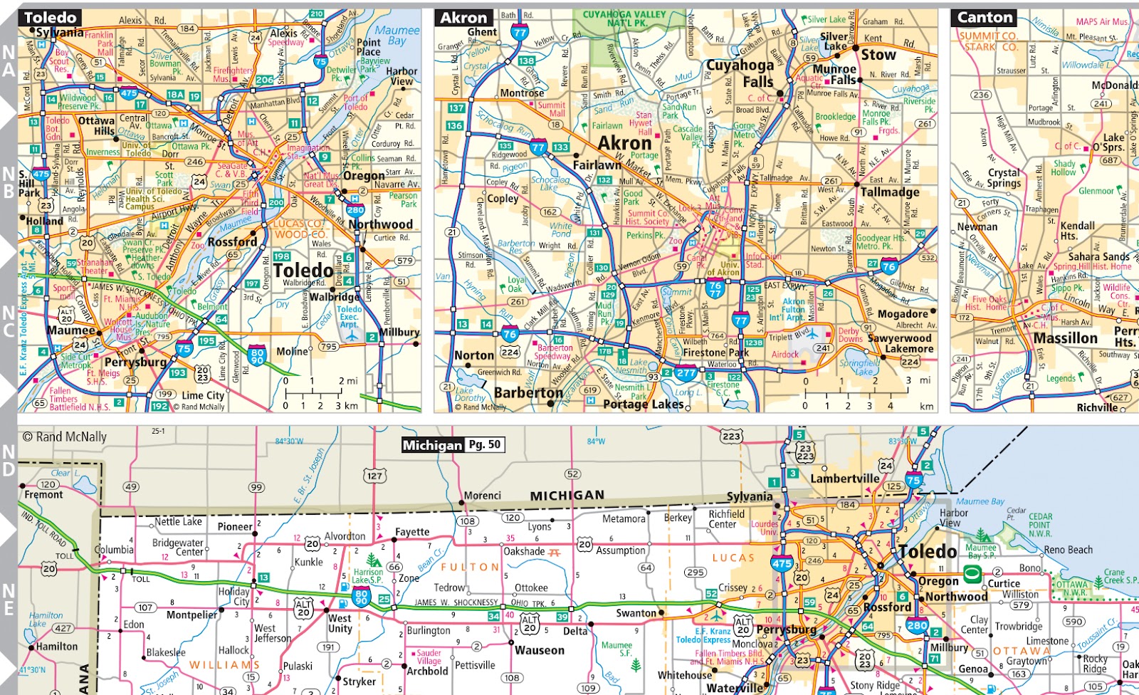
Pictured: Road Atlas section of northeastern Ohio and the Toledo area.
Finally, we do not base the inclusion of a city only on criteria such as population (although it is a major factor) as we often try to evenly space map content across the state for a more balanced map if possible.
Question 3: What happened to the city elevations you used to show on the maps?
We did include elevations for select cities on the map (like Denver and other smaller cities below on the 1948 map) for many years. When our map database was rebuilt around 2010, we decided to remove the labels for city elevations because we felt these labels took up valuable space on the map and were not as important to include as other map features like towns, points of interest, parks, etc. Also, we updated the fonts used on the maps and chose a more legible, clean font with a larger footprint, so space was at a premium on the maps and elevation labels were cut for cities. We still show elevations for physical features like mountain peaks and passes, but for cities they are no longer shown.
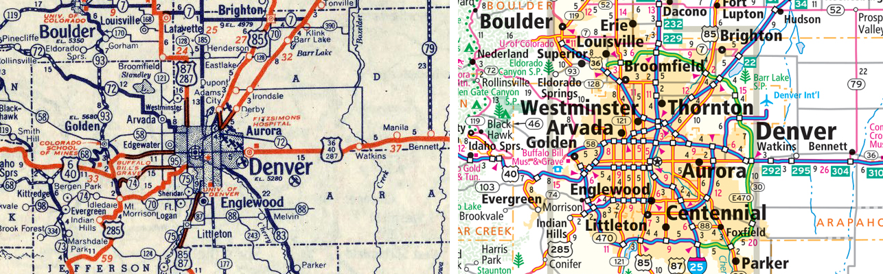
Pictured: 1948 Road Atlas with city elevations vs modern Road Atlas without elevations.
Thanks again for the question! I hope you found some of the most frequently asked questions and my answers interesting and please check in next week for more questions and answers in Part Two. Feel free to submit your map or cartography questions below and check back next Tuesday for another installment of "Ask a Cartographer".
Have a question for our cartographer? Email us at printproducts@randmcnally.com with “Ask a Cartographer” in the subject line and your question could be featured next.