
Lost in longitude or confused by contour lines? Want to know all the tips and tricks for getting the most out of your atlas? Curious if paper towns still exist? "Ask a Cartographer" is your opportunity to get the facts straight from the source. Tom Vitacco, Rand McNally Publishing’s Director of GIS is here to answer your burning questions, and geek out over fascinating map lore – one exploration at a time.
This week, we are discussing the most interesting map projections we've seen...
Question: What are some of the coolest or most unusual map projections you have come across?
Tom’s answer: What a great question and thank you for asking! Map projections can be incredibly complex, but also remarkably interesting, so I will try to keep my answer simple and provide a few examples of cool or interesting map projections we have used in Rand McNally Publishing products over the years.
Map Projections Defined
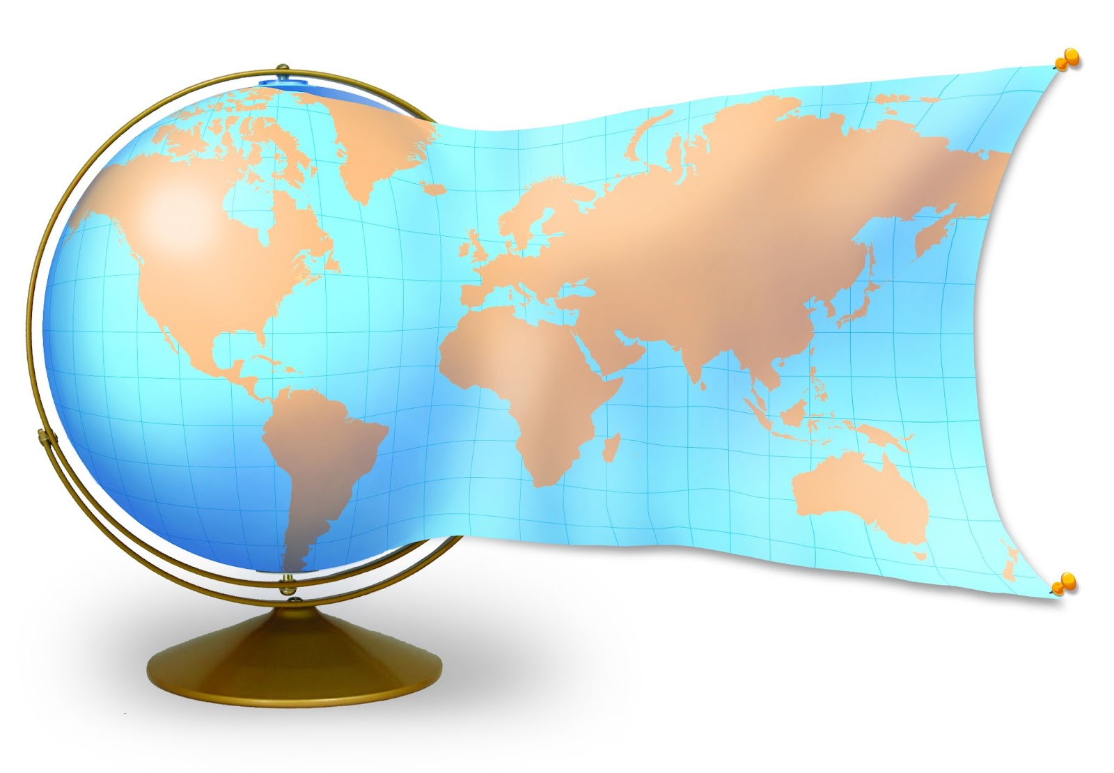
A globe is the best way to represent the spherical shape of the Earth and cartographers use map projections to represent the Earth’s surface on a flat surface such as paper or even in digital environments like GPS or online map engines. All map projections introduce some kind of geometric distortion for shape or distance. A cool visual example of this is shown below from a graphic used in our Classroom Atlas which helps illustrate the challenge of making a flat map of the round Earth. You must stretch the map in order to flatten it and this is where map projections come into play.
Interesting Map Projections
There are many cool or unusual map projections available that create stunning portrayals of a map with wild shapes and sizes. If you are interested, just search for projections such as AuthaGraph, Berghaus Star AAG, Bonne, Fuller, etc., and you will see some great examples.

Pictured: An example of the Fuller map projection.
One of the most common map projections is the Web Mercator projection which has become the standard for online maps and GPS devices. This projection works well for navigation because it creates a square shape for the entire world but for print mapping the Mercator projection is not ideal because of the distortion it introduces to land masses near the north and south poles.
Map Projections Used in Rand McNally Products
During my career as a cartographer, I have been truly fortunate to work with other cartographers who understood map projections and the math behind them extremely well, so I was able to learn from my coworkers how to use projections effectively for a printed map.
Here are three examples of the map projections we have used in print products at Rand McNally Publishing. First up is our World Wall Map series, which uses the Gall Stereographic map projection. We chose this “cylindrical” map projection because it attempts to balance the distortion present in all projections and has less distortion of scale and area near the poles. In the map image below, Greenland is not as stretched north and south as it would be if we chose the Mercator projection for the wall map.

Pictured: The Classic Edition of the Rand McNally Publishing World Wall Map using the Gall Stereographic map projection.
For the Road Atlas maps, each map layout uses a different map projection since we try to center the state or city map on the paper as best as possible. Most of the maps use the Lambert Conformal Conic projection, because “conic” projections near the mid-latitudes (like the US) distort less and hold the shapes of the states better.

My last example comes from Goode’s World Atlas, a college-level atlas we produced for many years. The Goode’s Homolosine map projection, developed by John Paul Goode in 1925, is used throughout the atlas because it minimizes distortion for the entire world, meaning continents are proportionally sized correctly to each other.

The Goode’s Homolosine map projection is a combination of two other projections, the Sinusoidal and Mollweide map projections. The projection is unique because of the discontinuities in the ocean regions, which was done to reduce the distortion of the continental land masses as mentioned above.

Thank you for the question and I hope my answer helps to clarify map projections and how we use them as cartographers. Feel free to submit your map or cartography questions below and check back next Tuesday for another installment of "Ask a Cartographer".
Have a question for our cartographer? Email us at printproducts@randmcnally.com with “Ask a Cartographer” in the subject line and your question could be featured next!