
Lost in longitude or confused by contour lines? Want to know all the tips and tricks for getting the most out of your atlas? Curious if paper towns still exist? "Ask a Cartographer" is your opportunity to get the facts straight from the source. Tom Vitacco, Rand McNally Publishing’s Director of GIS is here to answer your burning questions, and geek out over fascinating map lore – one exploration at a time.
This week, we're discussing the most remote places on Earth...
Question: What are some of the most remote locations you have ever mapped?
Tom’s answer: What an awesome question…thank you for asking and allowing me to take a trip down memory lane. Coincidentally, a similar question came in recently from a customer inquiry which I will discuss as well so please check out the end of the blog for the answer to the “bonus question”.
As a cartographer, I have been fortunate to work on maps covering the entire world and there have been some truly remote places I have mapped during that time so I will try to answer your question by using examples from different products we created over the years. Also, it is worth pointing out that Rand McNally Publishing products typically focus on national travel, world reference, or classroom education. So, while a “remote location” might be included on a map we create, it is usually not the focal point of the map.
Remote World Locations
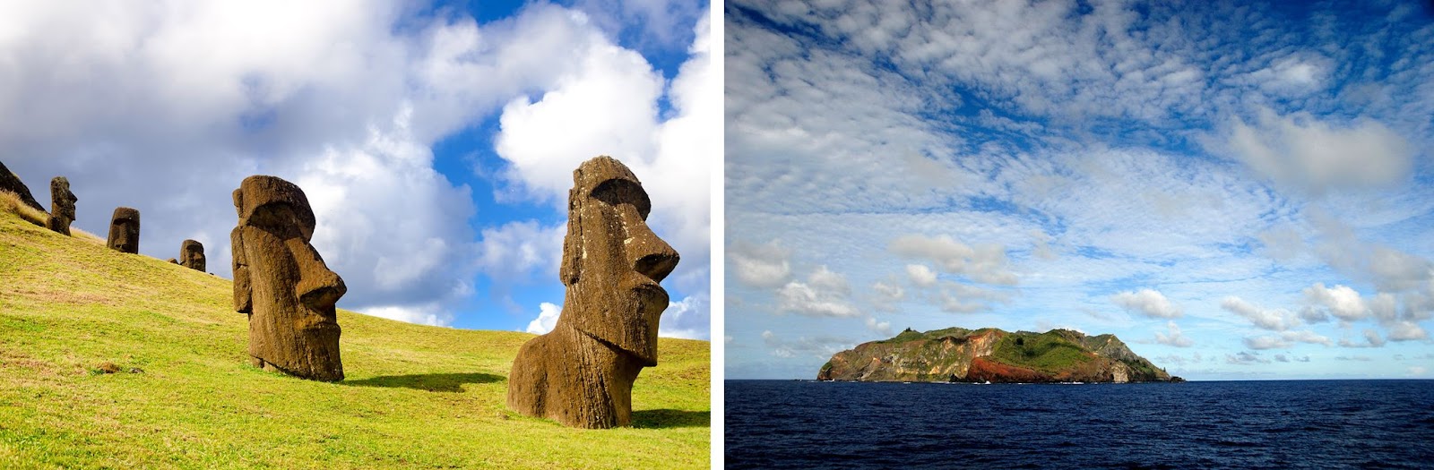
When I think of remote locations around the world, one of the first things that comes to mind are the vast oceans and all the small islands which can be truly remote places. Many are accessible only by boat or small planes and can be extremely far away from cities and populated places in general. Two examples would be Easter Island, far off the coast of Chile, and Pitcairn Island, part of the British Overseas Territory in the Pacific Ocean.
Pictured: Remote island locations such as Easter Island (left) and Pitcairn Island (right).
At Rand McNally Publishing, most of the remote islands we map are included on our ocean maps and shown at very small scales, although a few atlases have more detailed island “inset maps”. For example, earlier in my career we made many world reference atlases (known internally as “coffee table books”) and one college textbook (Goode’s World Atlas) and these atlases always included ocean maps with small inset maps of the islands like the maps shown below. I always found ocean maps to be fun to work on for a couple of reasons. One, they are challenging because of the generalization that occurs since the maps are small scale and as cartographers we need to make sure the islands are visible and labeled properly. Additionally, they are just interesting maps because of how remote and isolated some of the locations really are in relation to larger countries and land masses.
Pictured: A small-scale ocean map from a world atlas along with island “inset maps”.

Other remote locations would include the north and south polar regions. Maps of the Arctic Ocean and Antarctica were often featured in our world atlas products, and these polar maps were challenging to work on especially when placing labels on the projected map due to the curvature of the perspective. Two polar maps are shown below from Goode’s World Atlas.
Pictured: Remote locations in the North & South polar regions mapped for Goode’s World Atlas.

Remote Locations in the United States and Canada
Remote locations can be found beyond just the oceans or extreme polar regions, however, as the United States and Canada have countless remote areas when you consider their distance from road networks or cities. In fact, we have mapped a variety of remote locations in our road atlases throughout the years.
Some examples include the Frank Church-River of No Return Wilderness in central Idaho, the largest contiguous wilderness in the Lower 48 with few roads in the area. Supai, Arizona, located at the bottom of the Grand Canyon within the Havasupai Indian Reservation, accessible only by helicopter, on foot or by mule. Also, in the Northwest Territories, we added the Inuvik–Tuktoyaktuk Highway (Highway 10) a few years ago, the first all-weather road to Canada's Arctic Coast.
Pictured (left to right): Remote locations in the US and Canada including Frank Church Wilderness in Idaho, Supai, Arizona and Highway 10 in the Northwest Territories, Canada.

A couple more examples are found on our maps in Nevada. Jarbidge, is an extremely isolated mining town in northern Nevada nestled in the Humboldt-Toiyabe National Forest, where the best route to get there is hundreds of miles off the interstate and through multiple states. Plus, while not necessarily remote, we do include “the Loneliest Road in America”, a distinction first mentioned in Life magazine in the mid-80s for U.S. Highway 50 running through Nevada and later adopted by the state as a marketing slogan which remains in place today. We have labeled the scenic road as such on our Nevada maps for years.
Pictured: U.S. 50 running through Nevada, dubbed The Loneliest Road in America and Jarbidge, one of most remote locations in Nevada.

Null Island
As I mentioned earlier, we recently got a customer inquiry with a question about whether Rand McNally Publishing has any maps showing Null Island. The quick answer is no, we do not show this imaginary location on any of our maps. Null Island, or the location at zero degrees latitude and longitude where the equator and prime meridian intersect, is not really an island so there is no land at this junction. Originally the name was used within geographic circles as a way to help find errors in map databases because if the software couldn’t find a location it would assign a lat/long of “null,null” or “0,0”. The name and idea took off and became somewhat of an urban legend within the mapping community. I believe there was a weather buoy anchored there but I am not sure if it still exists.
Pictured: Map showing the location of “Null Island” at zero degrees latitude and longitude.

Thanks again for the question! Feel free to submit your map or cartography questions below and check back next Tuesday for another installment of "Ask a Cartographer".
Have a question for our cartographer? Email us at printproducts@randmcnally.com with “Ask a Cartographer” in the subject line and your question could be featured next.