Lost in longitude or confused by contour lines? Want to know all the tips and tricks for getting the most out of your atlas? Curious if paper towns still exist? "Ask a Cartographer" is your opportunity to get the facts straight from the source. Tom Vitacco, Rand McNally Publishing’s Director of GIS is here to answer your burning questions, and geek out over fascinating map lore – one exploration at a time.
This week, we are discussing the Canadian maps shown in the atlas…
Question: We recently bought the 2025 Large Scale Road Atlas and love it. We noticed the Canadian provinces are not entirely shown. Why not?
Tom’s answer: Excellent question! Thanks for asking and for the kind words about the new Large Scale Road Atlas. You are correct that we don't show the entire province for some of the Canadian provinces. Canada has ten provinces and three territories and is quite large as a country, so I will do my best to explain why and point out a few of the differences between the U.S. and Canadian maps from a cartographic standpoint.
Canadian map coverage
To start, I have mentioned this in other recent blog posts, but it is worth repeating. We work with fixed page counts for any given atlas, so we must fit all the state, city, provincial and country maps we produce into the exact number of pages we have for each specific atlas. We include all the states and hundreds of cities mapped out at various scales in the Road Atlas product line. After the U.S. maps, we have Canada represented with an overview map showing the entire country except the extreme northern latitudes (see image below), and finally we have a small-scale overview map of Mexico with an inset map covering Puerto Rico which I will briefly cover later.
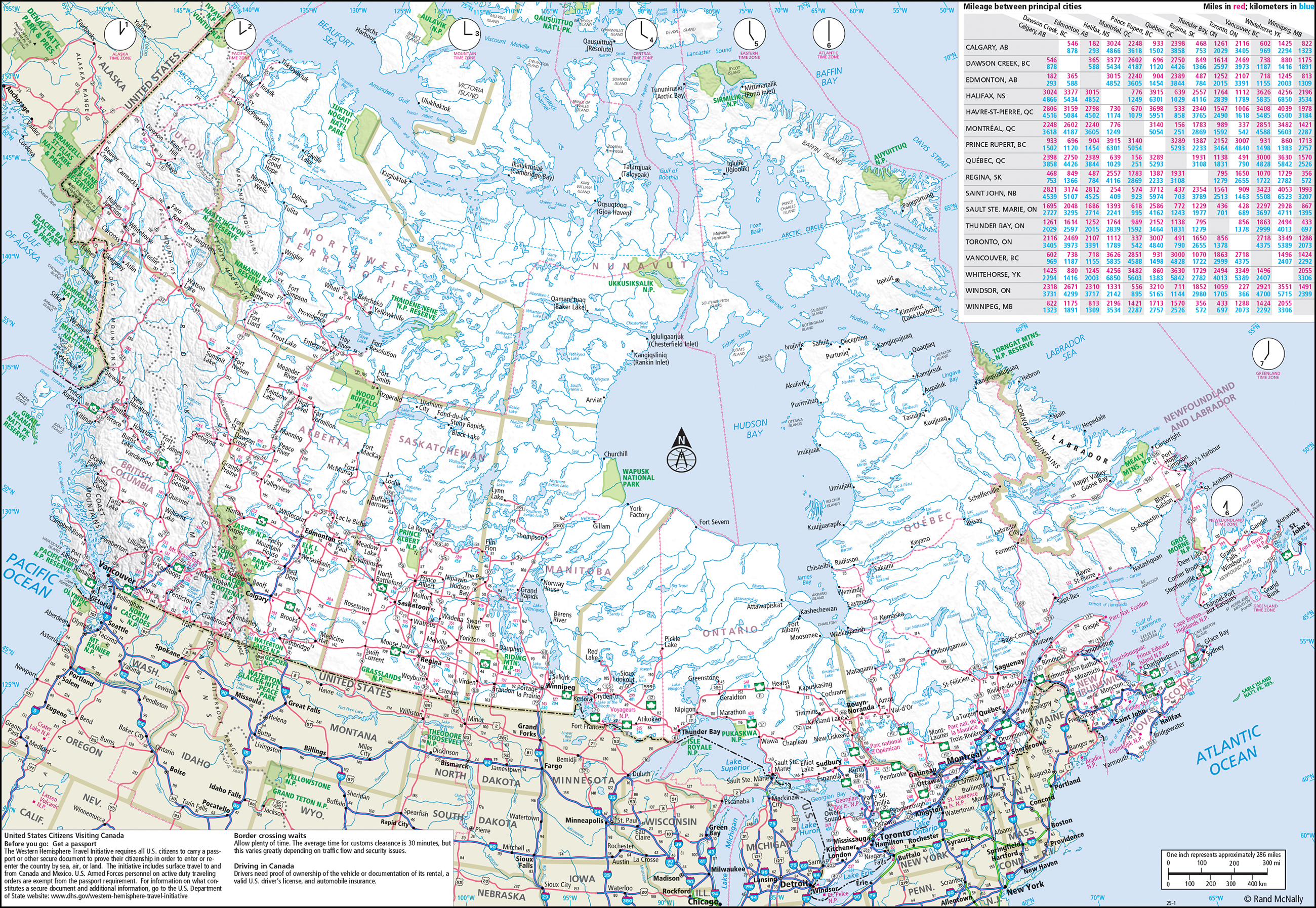 Pictured: Canada overview map from the 2025 Road Atlas.
In the Canada section, we include detailed provincial maps showing Alberta, British Columbia, Manitoba, New Brunswick, Newfoundland and Labrador, Nova Scotia, Ontario, Prince Edward Island, Quebec, and Saskatchewan. The other territories, which are Northwest Territories, Nunavut, and Yukon, are only shown on the Canada overview map (see image above).
On our detailed provincial maps, you will notice we do not cover the northern section for some of the provinces, although we do show the entire province for a few like New Brunswick, Nova Scotia, and Prince Edward Island. There are two main reasons for this omission. First, approximately 90% of the population of Canada lives within a couple hundred kilometers of the U.S. border for many reasons, including economic, social, and environmental considerations such as climate. So logically we map the areas closest to the border since most of the people, as well as the road network, are in the southern part of the country.
The other reason is that many of the provinces and territories are very large compared to the U.S. states and since our paper size doesn’t change, we would have to produce much smaller scale maps and therefore remove a lot of map content to show the entire province or territory on our fixed page size. So cartographically we decided to only map the heavily populated areas with the most roads using the best scale we could to fit the page size.
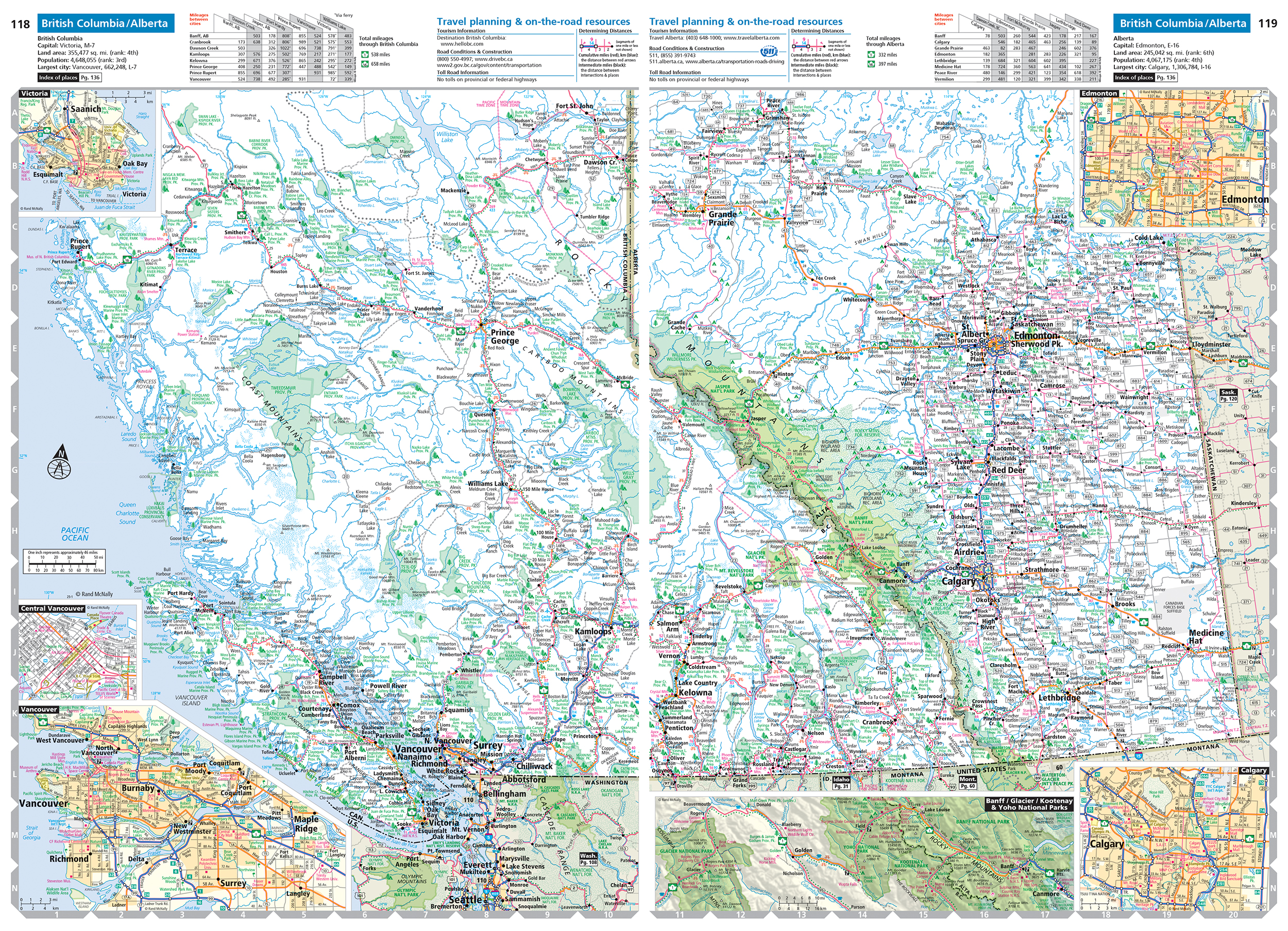 Pictured: The British Columbia and Alberta provincial maps from the 2025 Road Atlas.
As you can see in the map image above, while we do not cover the entire province for Alberta or British Columbia, we do include a lot of map content for the southern portion of the provinces while also fitting in a few detailed city or park maps within the page size for the atlas. As cartographers, we feel this layout and coverage is appropriate for these two provinces.
One other note on Canada: Occasionally, we will receive customer feedback stating, “You can’t use the road atlas to drive from the contiguous U.S. to Alaska through Canada”. In theory, you can. The Canada overview map does show the major roads that you would most likely use to drive from the “lower 48” north to Alaska, although the map detail is sparse and only the major roads are shown in Yukon and other northern territories.
We do research and update the Canada overview map annually, though, and have added or modified highways such as the all-weather Inuvik–Tuktoyaktuk Highway (Highway 10), and recently changed the map spec for the last remaining unpaved sections of the Trans Labrador Highway (Routes 500 and 510), since the entire road is now fully paved.
Cartographic differences
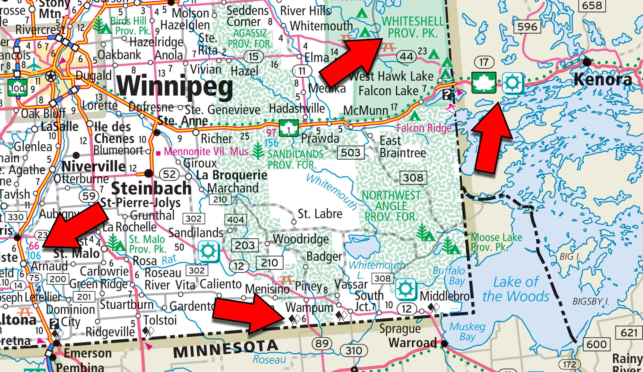
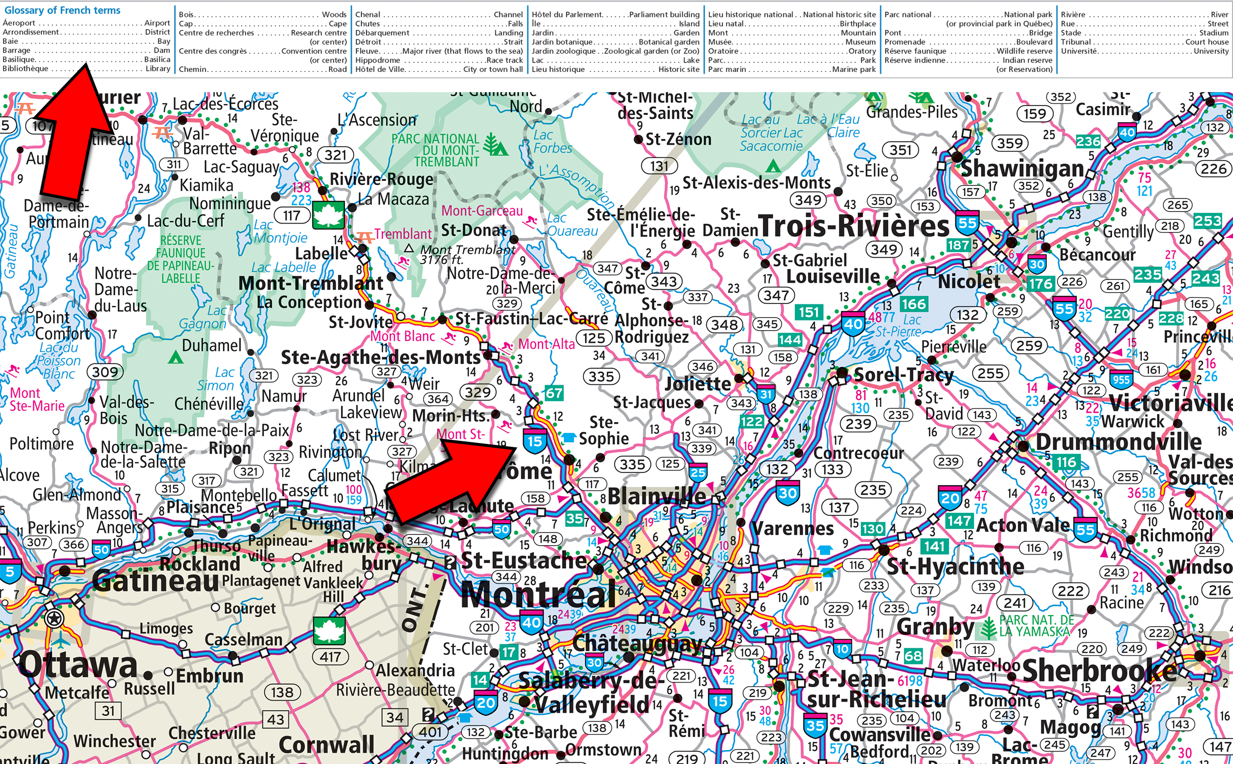
Our Canadian maps do have a few subtle map style differences compared to the state maps in the atlas and I will mention a few for clarity, all of which are depicted with the red arrows in the map image below. First, we follow the Trans-Canada Highway, a federal–provincial highway system which travels through all ten provinces, using the “green maple leaf shield icon” along the route. We also show some of the specialty routes we highlight in the U.S. when they cross into Canada such as the Great River Road icon shown below in various locations.
In terms of mileage, we include kilometers in the small cumulative mileage numbers shown on the map in blue (red number is for miles – same as the U.S.) and we display small “flag icons” which indicate border crossing locations. Additionally, Canada has Provincial Parks, which are administered by the province, and we label them accordingly with both green polygons and smaller tree icons, similar to parks in the U.S.
 Quebec, the second largest province in population, features the Autoroute system, a network of freeways operating under the same controlled access principles as the Interstate Highway System in the states. The highway shield icon uses a similar style as the Interstate Highway icon we show on the state maps as shown below. There is also a Glossary of French terms as part of the Canada overview map which can be useful with some of the eastern provincial maps.
Mexico and Puerto Rico
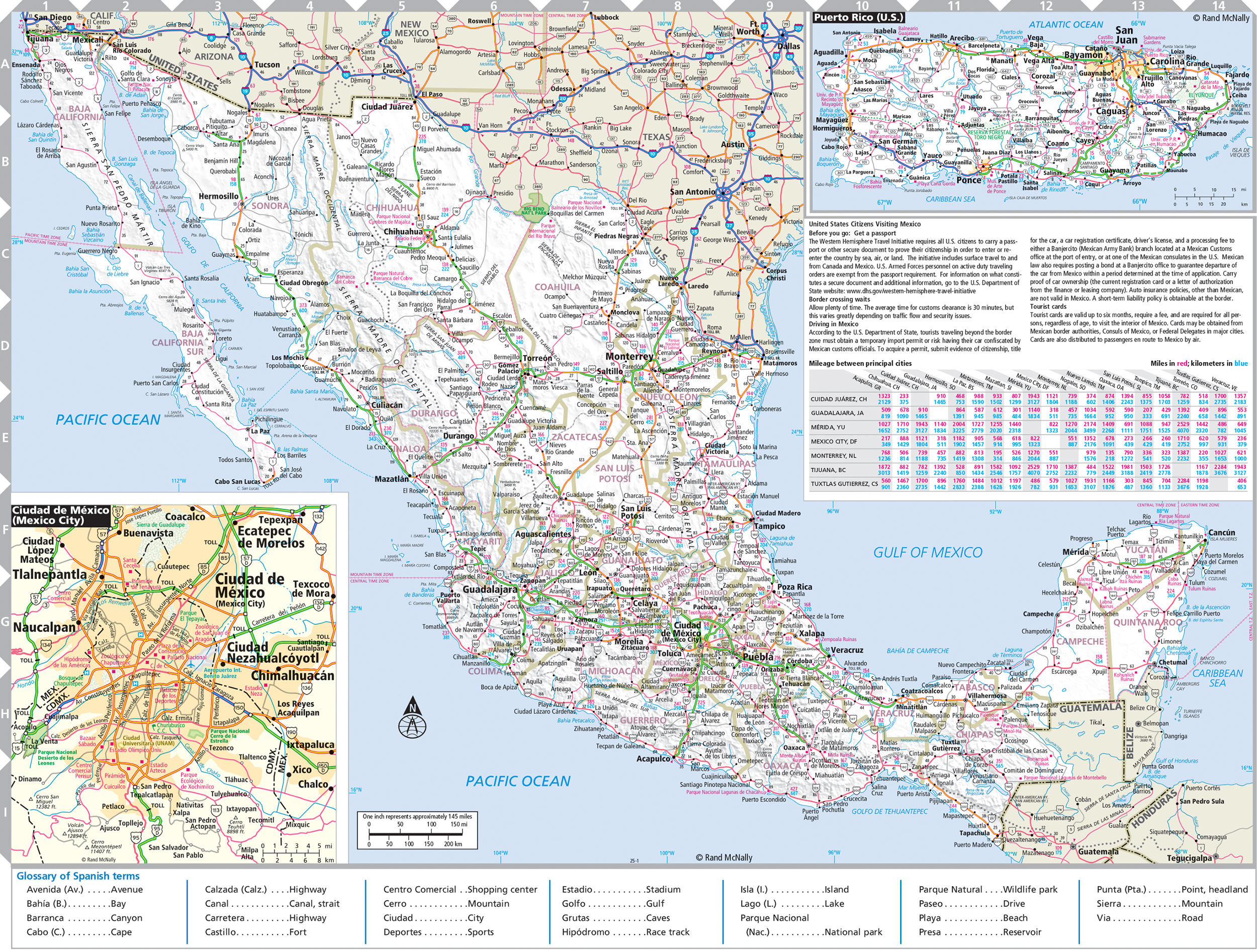
Finally, we make an overview map of Mexico as shown below which includes an inset map of Mexico City, a glossary of Spanish terms and a brief summary of rules and regulations for U.S. citizens traveling to Mexico. Please note the Mexico map is not really a detailed road map and more of a reference map for the country. Also on this page is a small inset map of Puerto Rico showing some of the major roads, cities, and points of interest for those traveling to that U.S. territory.
Thanks again for the question! Hopefully, I was able to provide some insight into the cartographic differences between our maps of Canada and the U.S., and the reasoning behind why we do not show the entire province for some maps. Feel free to submit your map or cartography questions below and check back next Tuesday for another installment of "Ask a Cartographer".
Have a question for our cartographer? Email us at printproducts@randmcnally.com with “Ask a Cartographer” in the subject line and your question could be featured next.


