
Lost in longitude or confused by contour lines? Want to know all the tips and tricks for getting the most out of your atlas? Curious if paper towns still exist? "Ask a Cartographer" is your opportunity to get the facts straight from the source. Tom Vitacco, Rand McNally Publishing’s Director of GIS is here to answer your burning questions, and geek out over fascinating map lore – one exploration at a time.
This week, we're discussing how to use the new Rand McNally digital maps on Avenza.
Question: I saw you announced you now have digital maps available. Can you tell me how they work and what you can use them for?
Tom’s answer: Thank you for the question! Yes, we recently announced that our state maps are now available for the first time in digital formats, and you can use the maps on your favorite device. The digital maps are sold on the Avenza Maps platform and we offer state, regional and U.S. maps at varying price points. The digital maps offer the same map content as our printed state maps, so you are getting the quality and reliability you have come to expect from Rand McNally Publishing in a portable and easy-to-use format. You can use digital maps just like you would a printed map, whether planning your route, navigating while driving, or finding interesting stops along the way.

Pictured: Rand McNally Publishing state maps available on the Avenza Maps platform.
Where to Find Rand McNally Digital Maps
You can download our digital maps directly from the Avenza Maps website or via their mobile app and use them together with printed maps or other digital maps. The state maps are georeferenced, meaning your location will be accurately spotted on the digital map if you are using the GPS functionality on your device. Also, the Avenza Maps app offers many interesting features, including the ability to mark places of interest, add notes, photos, or information about locations, track your route and even measure distances. Plus, the app works when you do not have cell service or network connectivity, so it is the perfect tool for your offline map adventures!
Pictured: Avenza Maps app features include adding photos, additional information, GPS tracking and measuring distances.
How to Use Our Digital Maps on a Trip
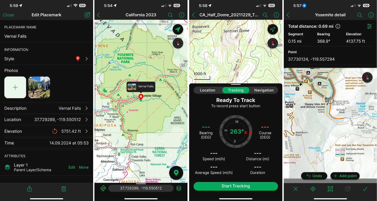
Here’s how I used the Avenza Maps platform and app on a recent trip my wife and I made to Yosemite National Park in California. The first thing I did was pack the printed state fold map for California because I always have a paper map with me when I travel. I decided not to bring a full road atlas on the trip since we were flying and only planning to be in California.
Next, I installed the Avenza Maps application on my iPhone (available on Android as well). Once installed, I searched the map store for the Rand McNally Publishing California state map and installed that map on my phone. I also downloaded a detailed USGS topographic map of the Half Dome area since I knew we would be hiking in that part of the park.
Additionally, on the National Park website for Yosemite, they offer the actual printed park maps as a GeoPDF file, meaning the map is georeferenced to real coordinates and therefore spatially accurate. Since the Avenza Maps app lets you download files from a Dropbox account, I uploaded the GeoPDF maps to my personal Dropbox account and downloaded the two National Park maps to my phone to go along with the state map and the topo map I had already installed. My phone was loaded with digital maps, and I had my printed state map as a backup, so I was
ready to go!

Pictured: Multiple maps loaded into the Avenza Maps app with accurate spatial tracking in use (shown by the small blue dot on the maps).
Using Digital Maps to Complement Navigation Apps
We flew into the San Francisco Bay area, and I used a popular navigation app on my phone to run a route from the airport to Oakhurst, the town outside the park where we were staying. The app offered many different routes, so I opened the Avenza Maps app, loaded our California state map, and used the state map to decide which route was best for me. I often use our printed maps in conjunction with online maps to plan routes because the printed map offers a bigger picture of the area, and the map design helps in planning and decision making.
For example, one of the routes followed CA-140 across the state while another route followed CA-152. I referenced our state map because I wanted to see the road hierarchy which isn’t always obvious in routing apps. I immediately noticed CA-152 was a four-lane divided highway for most of the route with only one larger city along the way, while CA-140 was a two-lane highway with more towns to travel through. I chose CA-152 because I knew the four-lane road would move faster than CA-140 which also appeared to traverse more mountainous terrain based on the curvature of the road on our map northwest of Oakhurst. So, while the routing app gave me options, I used the paper map to make the decision on which route I wanted to use.

Pictured: Digital version of our California state map shown in the Avenza Maps app with CA-152 shows as a four-lane highway for much of the route.
Digital Maps for Hiking in the Park
Once we got to the park, I used the topographic and the National Park maps to track our path, shown by the small blue dot on the images above, while hiking on the different trails. We used the app during two different hikes, first to Sentinel Dome and then we followed the Mist Trail to Vernal Falls. It worked perfectly and was a great resource in helping us decide which path to follow during our hikes.

Thanks again for the question! I hope this answer provides some insight into how to use digital maps. Feel free to submit your map or cartography questions below and check back next Tuesday for another installment of "Ask a Cartographer".
Have a question for our cartographer? Email us at printproducts@randmcnally.com with “Ask a Cartographer” in the subject line and your question could be featured next.