
Lost in longitude or confused by contour lines? Want to know all the tips and tricks for getting the most out of your atlas? Curious if paper towns still exist? "Ask a Cartographer" is your opportunity to get the facts straight from the source. Tom Vitacco, Rand McNally Publishing’s Director of GIS, is here to answer your burning questions, and geek out over fascinating map lore – one exploration at a time.
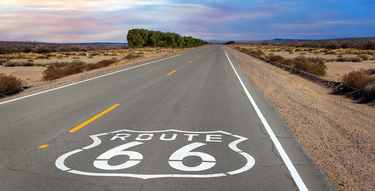
This week, we are discussing how Rand McNally was influential in the development of the US Highway Numbering System still used today…
Question: "I heard Rand McNally helped develop the Highway Numbering System. Is that true?"
Tom’s answer: I figured at some point a question related to the Highway Numbering System would be asked after we started the cartography blog over a year ago, so thank you for the submission. I did reference this topic briefly in an early post about street names, and I will include a link to that blog here if you did not get a chance to check it out last year.
To quickly answer the question, it is true that Rand McNally helped develop the Highway Numbering System still used today, and I will elaborate more below. The important part to remember is the phrase “helped develop” since there were many other groups, organizations, individuals and companies involved in the development of the highway numbering system as well. The perception that Rand McNally invented the highway numbering system is based on some facts but in reality, there is more to the story.
First, I wanted to mention that much of the information below was provided by Steve Wiertz, a Sr GIS Analyst here at Rand McNally Publishing. Steve leads our research team and has made numerous visits to the Newberry Library in Chicago to compile historical information about the company. I do find this topic fascinating from a cartographic perspective, so I will try to summarize what happened at the turn of the century and highlight some of the innovative mapping developments used by the company at the time for this blog.
Early Road Travel
There is a lot of information available online and at various libraries related to early road travel and the beginnings of the automobile, so I will not go into detail on those topics here. However, I did want to start with a brief summary related to road travel during the late 1800s and early 1900s.
At the beginning of the 20th century, road travel was not common but was on the rise, characterized by the transition from horse-drawn carriages and bicycles to automobiles. Most long-distance travel was still done by train, but road construction was becoming a priority as the “Good Roads Movement” was gaining momentum, which pushed for improved roads to accommodate automobiles between cities, towns and even National Parks like Yellowstone. After Henry Ford introduced the affordable Model T, auto sales rapidly increased and the materials used to build roads and parts like tires were improving, leading to an increase in road construction and travel. With additional travelers, businesses were now opening more locations along the roads to serve the traveling public.
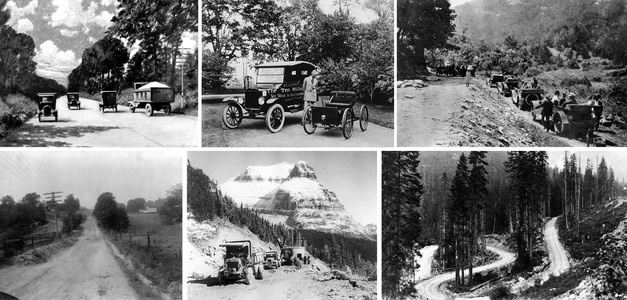
During this time, there were many private associations and organizations outside of the actual government promoting the development of named “auto trails” to encourage cross-country travel. The associations consisted of automobile clubs, oil and tire companies, local business leaders, and even departments of tourism. The movement started in states such as Iowa, Wisconsin, Michigan and Illinois. These auto trails were an informal network of marked routes for motorists, some spanning multiple states or even from coast to coast, and they were labeled with descriptive and utilitarian names and not the usual numbers we use today. The trails were often marked on utility poles or with painted signs along the roadside, usually maintained by volunteers or local groups or organizations. The local groups coordinated the installation of these visual markers to help motorists navigate before road numbers existed. I find this interesting since one could consider the auto trails concept as the beginning of the navigational systems still used on a daily basis today.
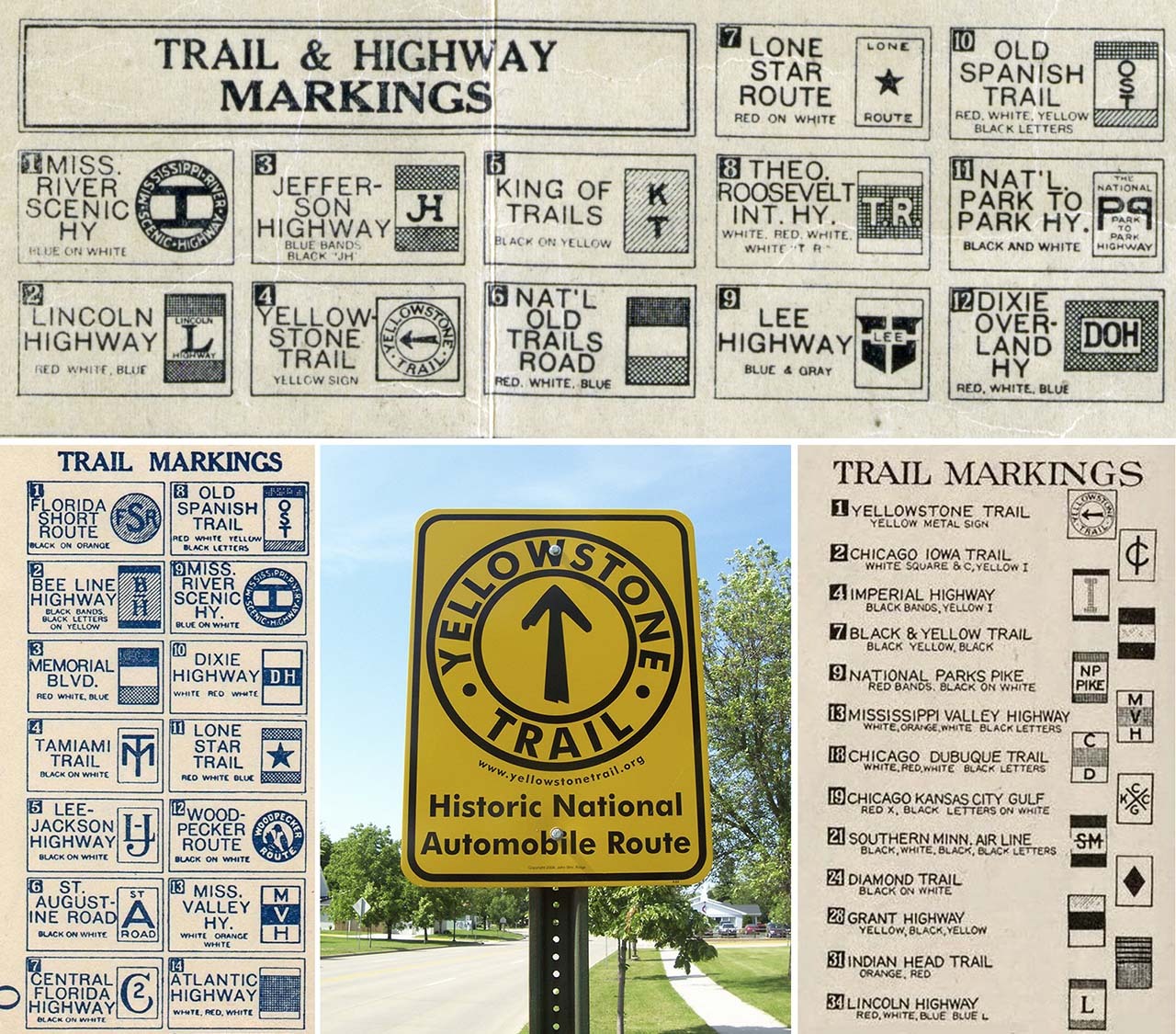
Some examples of auto trails from that era include the Lincoln Highway, the Dixie Highway, the Yellowstone Trail, and the National Old Trails Road. The image below highlights the unique marker styles along with a current sign paying tribute to the historic Yellowstone Trail.
Auto Trails Maps
As the auto trails movement gained acceptance and popularity, highway associations and different state agencies began to experiment with route numbering systems and simplistic maps to alleviate the issue of inconsistency and individualism found with the markers. Wisconsin started using numbers and signs in 1916 which followed the state “trunk highway” system, while Illinois began using the state “bound highway” designations and Michigan had the “M” system it still uses today. The maps were often in a “strip” format using a verbal itinerary style with the route being the focus of the map and cities labeled at right angles similar to earlier railroad maps. The problem was the maps were not useful as navigational tools because of inconsistencies between all the different companies and associations producing the maps.
Rand McNally addressed this problem with the introduction of the national Auto Trails map collection in 1917, a comprehensive set of maps showing all the roads designated by the different highway associations, companies and state agencies. The company focused on accuracy and consistency by ensuring the routes marked on the maps were marked the same along the road, creating the most useful product at the time. In fact, many Rand McNally employees were tasked with marking some of the routes shown on the maps out in the field.
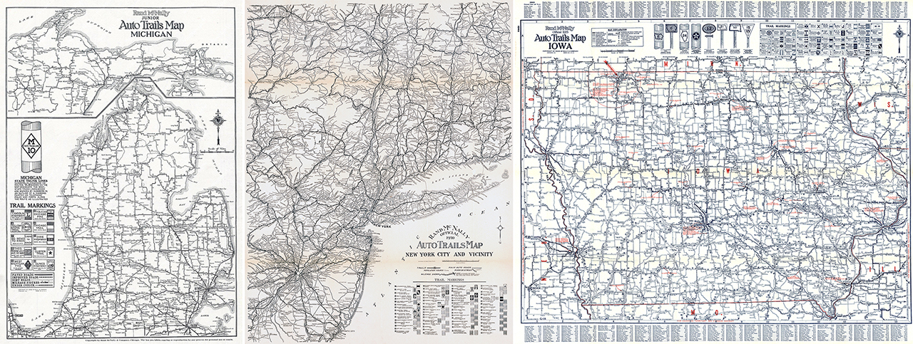
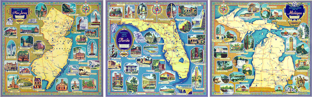
Pictured: early Auto Trails Maps of Michigan, New York City & Vicinity, and Iowa.
The idea for the Rand McNally Auto Trails Maps series was created by John Brink, a contract cartographer at the time and an auto travel enthusiast, who in 1916 suggested the concept for a standard set of easy-to-use auto road maps. His idea was to use numbers, which fit on the map better than the longer trail names, along with an associated map legend, saving space on the map layout for advertising and promotional materials. The idea took off and soon John became the head of the “Blazed Trails Department” that printed road maps of states by region.
A skilled artist, John Brink also created numerous Pictorial Maps during his long career as a cartographer at Rand McNally. He introduced the idea to help differentiate Rand McNally products from their competitors and created many of these artistic maps during his decades long career with the company. Some examples of his artistic talent are shown in the map images below.
In 1921, the first Transcontinental Auto Trails Map of the United States was published, and by 1922 the company completed a set of road maps for the forty-eight states. This set of maps eventually became the Auto Chum in 1924 and finally the Road Atlas which we still produce today.

Pictured: a cartoon created when the Blazed Trails department was formed (left), along with a section from a 1925 Auto Trails Map (center), and John Brink working on a Pictorial map.
Around 1926, federal and state agencies started to focus more on highway numbers and developing new laws related to highways, leading to the formation of the National Highway System and a uniform marking system for road numbers. The creation of this system was the beginning of the end for the Auto Trails program, especially once the new state and US highway route numbers became the norm for road travel and navigation. Some of the trail names still linger on today, but the colored markers on the old roadside utility poles have long since faded away.
Auto Trails Cartography
As a cartographer, I find the early Auto Trails Maps to be very intriguing and innovative. These maps provided comprehensive highway navigation by offering route numbers, travel amenities, road conditions and even commerce. These maps were the precursor to the Road Atlas, and I wanted to point out a few things I noticed when reviewing some images of the old maps.
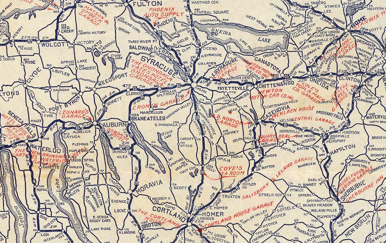
The image below is a crop from the 1920 New York Auto Trails Map, and I listed some items which I found cartographically interesting here:
- The use of numbered squares to highlight the Auto Trail and the corresponding legend entry with the full name of the trail.
- Points of Interest are shown in red (still use this style today) and the included POIs are road travel focused like hotels, repair shops, auto supply and food stops.
- Mileages are shown between locations.
- Populations are listed next to the city or town label when space permits.
- The labels are rarely horizontal and straight (our standard convention today) and similar to the older railroad maps made by the company.
What is intriguing to me is that we still use most of these mapping conventions or styles in the current version of the Road Atlas over one hundred years later.
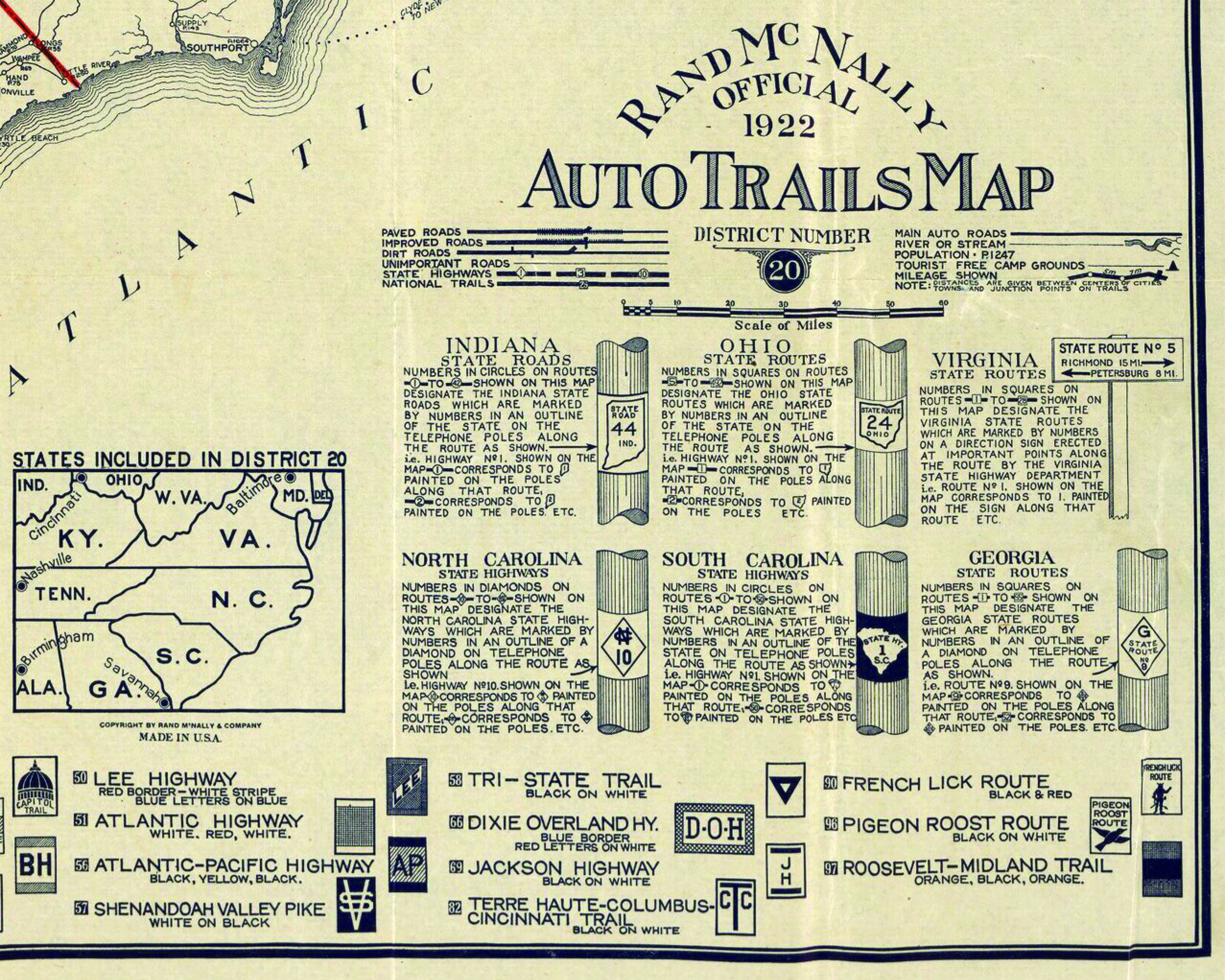
When looking at a map legend like the sample below from 1922, I like how the cartographers included verbal descriptions of highway routes for different states, along with the trail marker graphics and names. Plus, the inclusion of the “utility pole” graphic showing how the signs might look on the road was inventive and useful at the same time, illustrating how Rand McNally cartographers were focused on clarity and accuracy even back then. After looking at many examples of the Auto Trails Maps, it has quickly become my favorite product line from the Rand McNally archives, and I plan to look for a high-quality print of a state map to hang in my office one of these days.
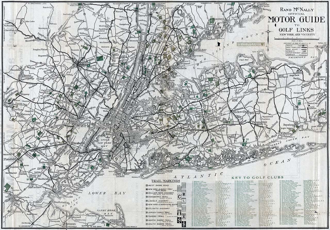
Auto Trails Golf Map
Finally, although I am by no means a good golfer, I do try to get out on the course a few times each summer, and I came across this Auto Trails map which shows the Golf Links in the New York City area and wanted to highlight it here. The map shown below is called the Official Motor Guide to Golf Links and stylistically it looks like an Auto Trails Map based on the map markings and the legend, so I believe it was a derivative of the New York City Auto Trails map created for the golf community. I found it really cool and thought I would share it at the end of the blog to show how the company was creative in their product spin-offs back in the day.
 In conclusion, there were many groups, agencies, and organizations involved in the development of the Highway Numbering System. I hope I was able to provide some informative background information here and highlight Rand McNally’s involvement in the creation of the system while also demonstrating how innovative the cartographic staff was at the time.
Thanks again for the question! Feel free to submit your map or cartography questions below and check back soon for another installment of "Ask a Cartographer".
Have a question for our cartographer? Email us at printproducts@randpublishing.com with “Ask a Cartographer” in the subject line and your question could be featured next!