
Lost in longitude or confused by contour lines? Want to know all the tips and tricks for getting the most out of your atlas? Curious if paper towns still exist? "Ask a Cartographer" is your opportunity to get the facts straight from the source. Tom Vitacco, Rand McNally Publishing’s Director of GIS is here to answer your burning questions, and geek out over fascinating map lore – one exploration at a time.
This week, we're answering more of our most frequently asked questions from customers.

Question: What are some of the most frequently asked questions about your maps or products?
Tom’s answer: Last week we covered three of the more common questions we get about our maps or products and this week we will continue with Part Two by answering a couple more frequently asked questions.
As a quick reminder, the easiest way to ask a question or to provide feedback about our maps is to send a message to printproducts@randmcnally.com, an email account monitored by the GIS team here at Rand McNally Publishing.
Question 1: Why are the maps “chopped up” in the Large Scale Road Atlas?
We get a lot of questions or comments related to the layout or format of this atlas, so I felt this was a good opportunity to quickly explain why the maps are “broken up” in the Large Scale Road Atlas. Most customers love this larger atlas, as evident by the many 5-star reviews, because it is easier to read and the spiral binding allows the maps to lay flat, but sometimes the “gutter” between the pages or the method we use to split the state maps causes confusion.
It is important to note that we are printing to a fixed medium (paper) at a fixed size, and we must fit states of all shapes and sizes onto this paper. We also have page counts we try to maintain to keep the atlas at a comfortable size and weight for use while traveling.
With that in mind, we need to be creative as cartographers to choose appropriate map scales and layouts for the maps within our Road Atlas product line. Plus, we include city and park “inset maps” on the page as well in areas outside the subject state and need to account for those maps within the allocated space.
Here is a good example. Indiana as a state has a relatively simple shape with mostly straight lines on three of the borders. Indianapolis, the largest city, happens to be near the middle of the state geographically, which means on a four-page map spread it will show at the bottom edge of the page as shown below. We could shift the state left, but then Indianapolis would land on the edge of the page and within the gutter area plus we would lose the space on the left used for city maps. If we scale the map up, we need more than four pages to show the state which does not help, and if we shrink the map down it becomes cluttered and hard to read with potentially wasted space around the borders of the state.
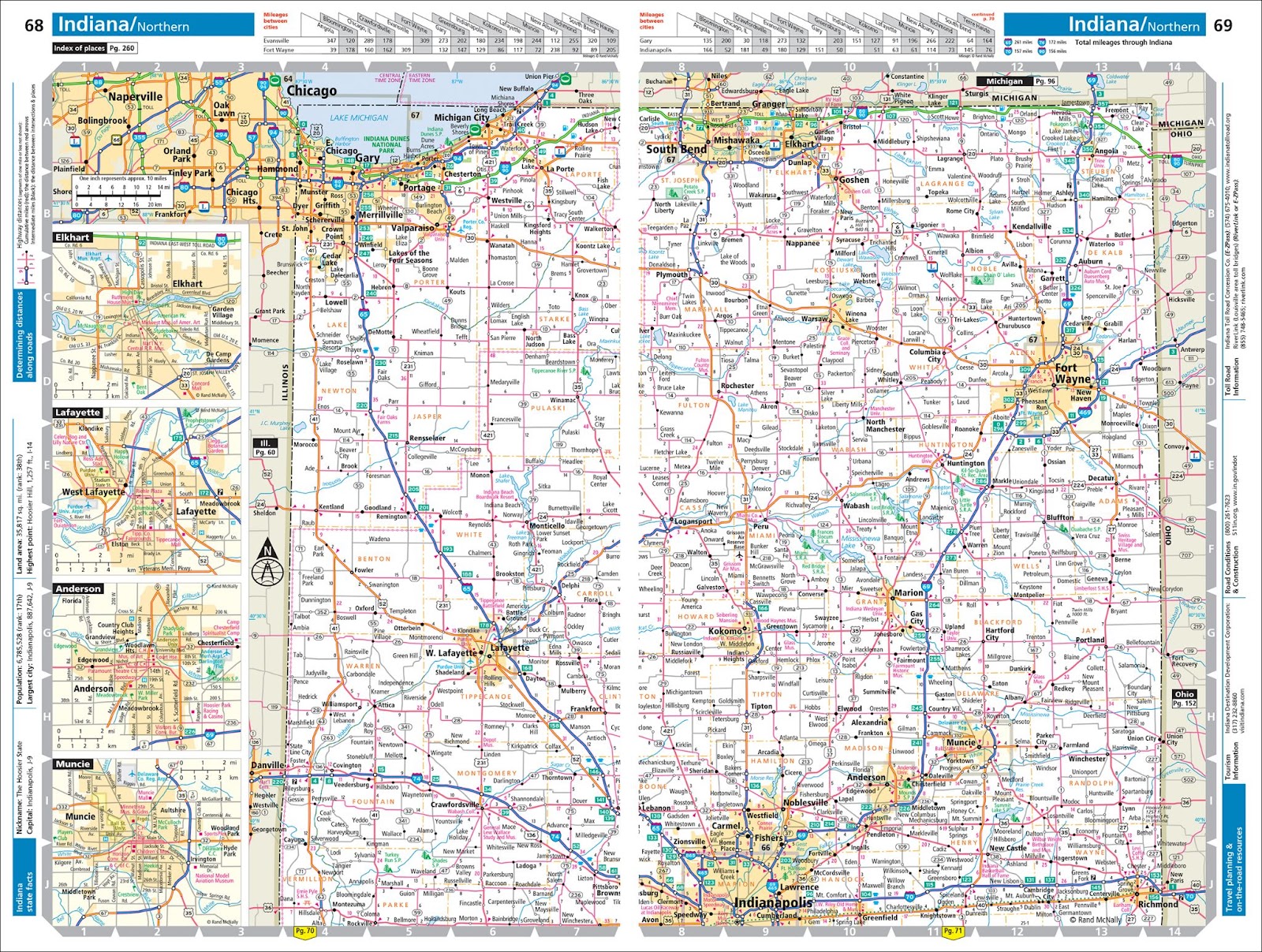
Pictured: Indiana map spread from the Large Scale Road Atlas.
So as cartographers we chose to balance the map scale with the size of the paper we are working with and unfortunately Indianapolis falls along the edge of the page, but the state map in general is readable, and we have room to include some city maps in the layout too. Plus, there is already a larger city map for Indianapolis on another page so cartographically we are ok with this layout even if Indianapolis is “chopped in half” unfortunately.
Another good example is Florida. We cut the “panhandle area” off from the main state and presented it like an inset map because the shape of Florida would require us to shrink the map down way too much to fit on the paper used to print the atlas. To keep the map legible, we must “chop it up” to fit the layout and format since our chosen paper is at a set size and orientation.
Cartographic decisions are made for every page in each product like the processes described above. In the end, fitting all the maps and surrounding textual information within the confines of a fixed medium like paper is more complex than it seems, and ultimately the only way to display all the maps together is to “chop them up” when necessary!
Question 2: How often do you update the maps because I do not see any differences between my new and old atlases?
Yes, we update the maps annually for all the Road Atlases and spend quite a bit of time working on the research and update processes for our proprietary map databases. In fact, the amount of time we spend as cartographers updating the maps each year is one of the main reasons I believe our atlas is the best on the market.
Changes occur all the time that affect our state and city maps. These changes might include adding major highways and even minor roads, and the widening of roads from two to four lanes or “twinning” as they call it in Canada. Also, new interchanges and exits are added to highways, and adjustments are made to points of interest that open, close or change names or locations.
Occasionally, there is a new national or state park to include on the map, and towns will change names or switch from unincorporated to incorporated and vice versa. Some of these updates are easy to spot and others are very subtle, but we do update the map databases and our Road Atlases annually along with the textual information shown in the margins of the atlases.
Here are some examples of map updates completed for the 2025 Road Atlas:
1. Larger road updates
From left to right: Final section of I-69 added to the Indiana map south of Indianapolis; Texas Highway 249 extended northwest of Houston; West Davis Highway (UT 177) added near Ogden, Utah.

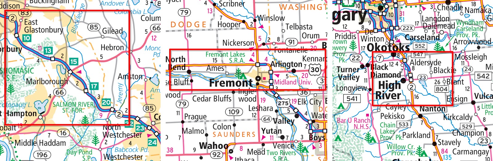
2. More subtle road updates
From left to right: New mileage-based exit numbers along Highway 2 in Connecticut; US 30 realignment in Nebraska; Highway 2 with new interchanges east of High River, Alberta, Canada.
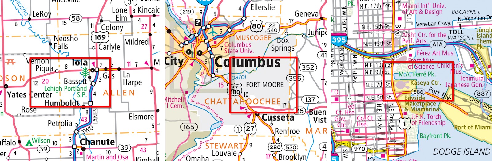
3. Park and Point of Interest updates
From left to right: Recently opened Lehigh Portland State Park added in Kansas; Fort Benning renamed to Fort Moore in Georgia; Kaseya Center became the new name for the basketball arena in Miami, Florida.
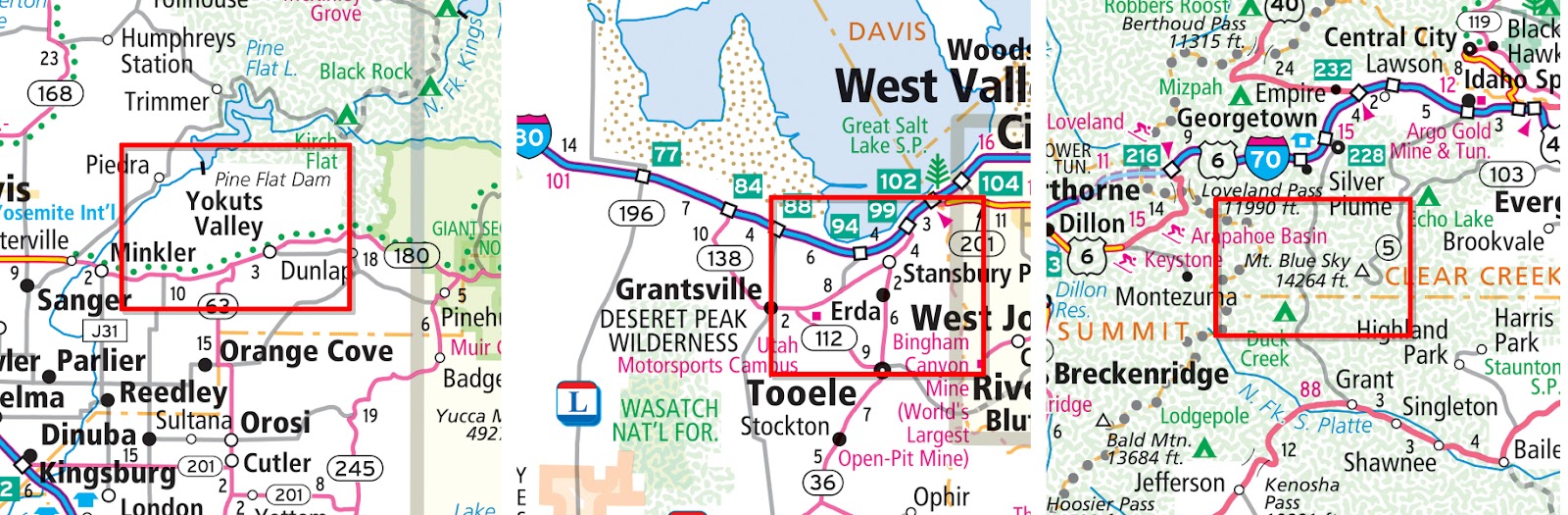
4. City or Physical Feature updates
From left to right: Town of Squaw Valley renamed to Yokuts Valley in California; Town of Erda in Utah is now incorporated so solid black dot is shown; Mount Evans renamed to Mount Blue Sky in Colorado.
These examples highlight the variety of map updates we research and implement annually in our proprietary map databases. The road atlases are up-to-date and accurate, and the maps are clean and legible, which helps Rand McNally Publishing products stand above the rest.
Thanks again for the questions and I hope you found some of the most frequently asked questions and answers interesting over the last two weeks. Feel free to submit your map or cartography questions below and check back next Tuesday for another installment of "Ask a Cartographer".
Have a question for our cartographer? Email us at printproducts@randmcnally.com with “Ask a Cartographer” in the subject line and your question could be featured next.