
Lost in longitude or confused by contour lines? Want to know all the tips and tricks for getting the most out of your atlas? Curious if paper towns still exist? "Ask a Cartographer" is your opportunity to get the facts straight from the source. Tom Vitacco, Rand McNally Publishing’s Director of GIS is here to answer your burning questions, and geek out over fascinating map lore – one exploration at a time.
This week, we are discussing cartographic challenges…
Question: What is the most challenging part of being a cartographer?
Tom’s answer: Thank you for the “challenging” question! I am sure if you asked other cartographers this same question you would get many different answers, so I will answer based on my personal experience working as a cartographer for a long time. Although I do plan to focus my answer on recent challenges instead of those I had working on a variety of map products in the past. Honestly, there have been a ton of challenges over the years now that I think back, such as building map databases from scratch, producing world atlases in different languages, or creating digital maps for navigation, but to keep this relatively short, I will just discuss a recent challenge we face today related to the Road Atlas product line.
For me, the most challenging part of being a cartographer today is related to the research and decisions involved in maintaining and keeping our map databases, and subsequently our printed products, current and accurate. The quality of our products is a major reason the Rand McNally name is one of the most trusted in the map industry. Overall, I am extremely comfortable facing challenges when it comes to cartography in general because I have been doing this type of work for a long time. However, staying on top of changes in the world, then applying those changes to our database and finally producing a timely printed map is what I find the most challenging these days. I will explain below what I mean with some real examples from our printed products.

Print Versus Digital
One of the challenges working with printed maps is once they are printed they are basically complete and in the hands of our customers for possibly a long time. We do update our maps annually and each year new versions of the map are potentially printed and available, but unless our customers buy a new map every year, then the products could potentially include out-of-date map content.
We release a new set of road atlas products every year, and the atlases are printed early in the year and available to purchase usually in the spring. Any changes that occur after the printing unfortunately need to wait until the next edition. Our customers generally understand this concept, but we do get customer feedback often related to something that has changed, but is not reflected in the atlas or map they bought. In general our customers are very understanding and share the feedback with us, which is greatly appreciated. Once we research the feedback, we add the change to the map update queue and usually the change makes it into the next edition of the atlas. So, if you notice anything you feel is incorrect or out of date in any of our printed maps, please send an email to printproducts@randmcnally.com and we will look into the issue as soon as possible.
Challenges with Printed Maps
Here are a few real examples to hopefully illustrate my point where we had to make decisions on map content based on print schedules and timing of the map change for the upcoming 2026 Road Atlas. Some of the challenges are easier to address than others.
First, there are simple changes we address like when a stadium changes its name due to corporate sponsorship or something similar. Usually, these name changes are announced in the media and take effect immediately or at the minimum the date for the name change is known, so for us it is easier to decide whether to make that change to our printed products. We first update the name change in our map database, then the next time the product prints the change will show up. A recent example is the Cleveland Browns football team changed their stadium name to Huntington Bank Field back in September, and as you can see in the map image below the name is already changed in our database and the new map will appear in the 2026 Road Atlas product line (which comes out in April 2025) and eventually the state fold and easy-to-fold maps. Plus, if a point of interest closes for good then we just remove it from our database and maps since there is not a “timing issue” to deal with so again this is an easier update to make.
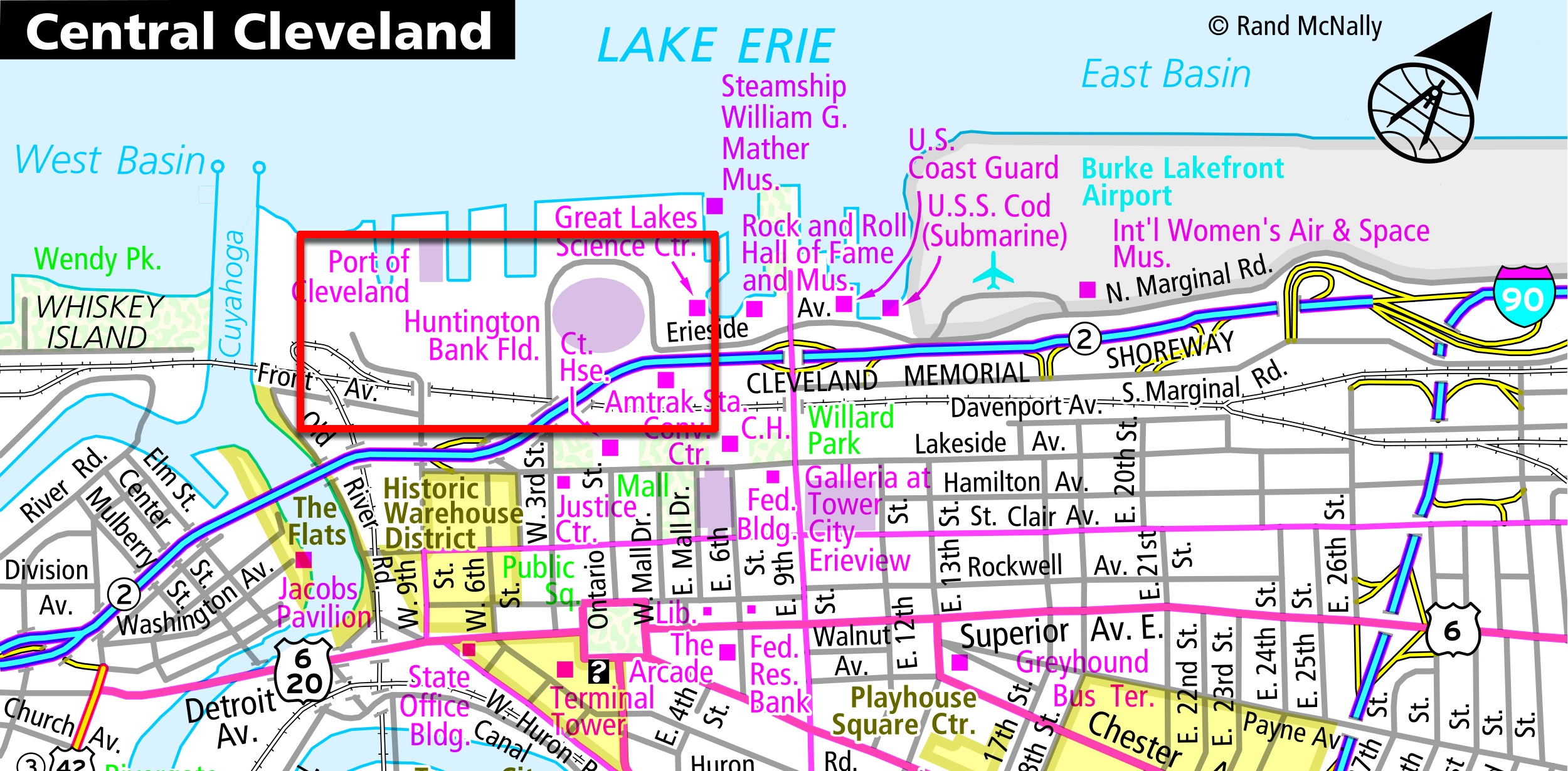
Pictured: New name for the Cleveland Browns stadium is already updated on our maps.
A more challenging map update would be the recent announcement that an Interstate 99 designation would be added to the US 15 route in Pennsylvania running north from Williamsport to the New York state line. The Pennsylvania Department of Transportation applied for this designation and AASHTO (American Association of State Highway and Transportation Officials) approved the change. In theory we could potentially add an I-99 highway shield to the map in Pennsylvania. However, since the final decision is pending FHWA (Federal Highway Administration) approval, we have to be more cautious about changing the map because if this approval takes years and we add the shield to the map we are potentially misleading our customers because they will not see I-99 signs on the road.
Our approach to this challenge was to reach out to the supervisor at the PA DOT listed on the request and we asked when signs might be added to the road by the department. They replied and said the I-99 signs most likely will not be added to the new interstate for two years, so we decided to hold off on this map update and not change the road to include the I-99 designation yet. We documented the change, placed it in our future update queue, and we will revisit the status next fall.
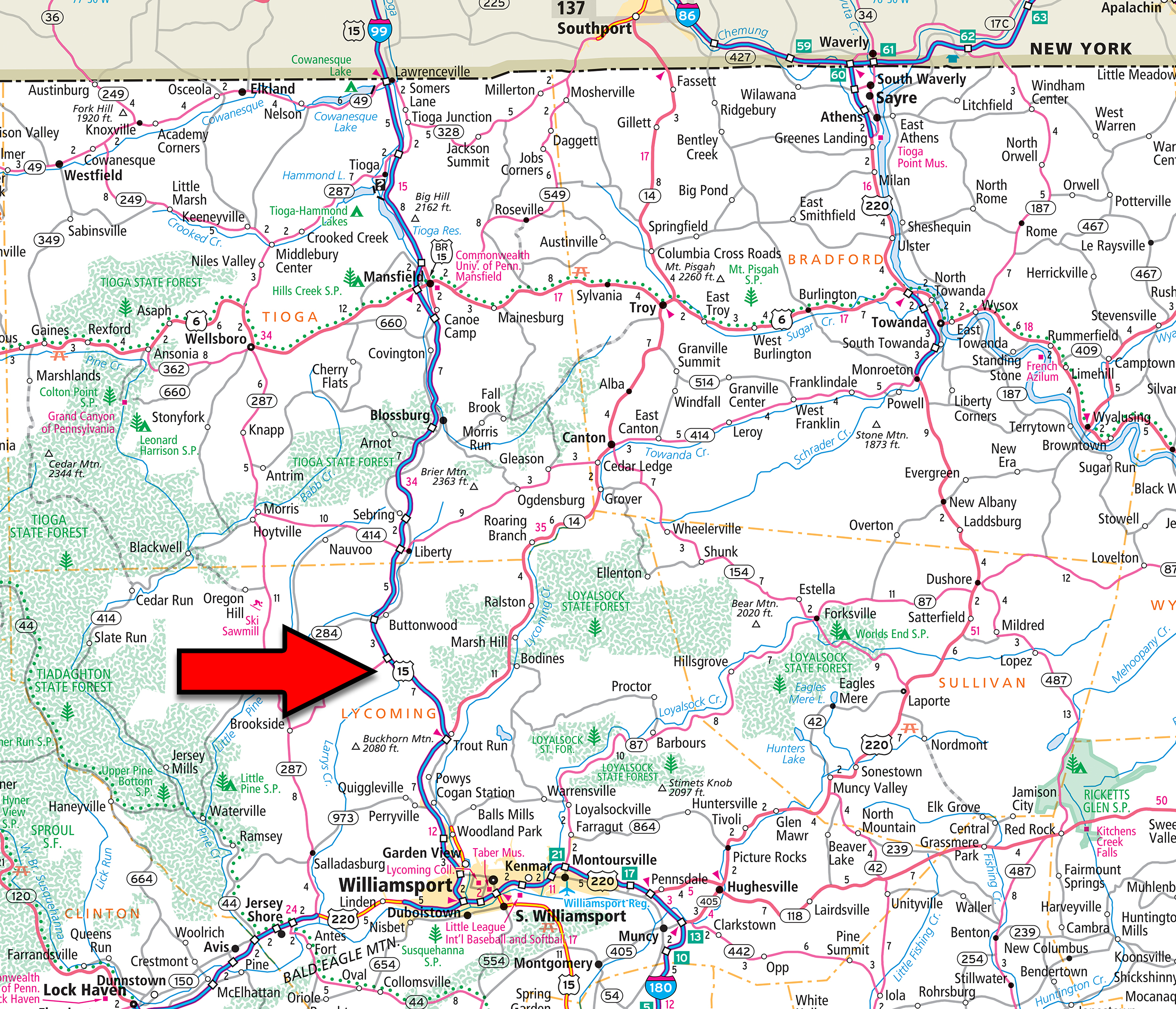 Pictured: The section of US 15 which will eventually become I-99 pending final approval from the Federal Highway Administration.
The last example I will offer is how we approach temporary road closures on a printed map. The best example I can provide is the I-695 bridge collapse last March when the container ship hit the Francis Scott Key Bridge near Baltimore. Since that is a major highway with a long-anticipated closure time, we will add a “note box” to the map with some detail about the closure and once the bridge is rebuilt and the road is open again, we will remove the note from the map. We do not use these floating note boxes very often on our maps. In fact, the only note boxes I recall were used for the I-35 closure in Minneapolis after the bridge collapse and I believe the US 90 highway closures due to Hurricane Katrina.
 Pictured: An example of a note we will include in the next edition of the Road Atlas regarding the bridge closure on I-695 near Baltimore.
Thanks again for the question! I believe that trying to stay on top of all the changes in the world, then figuring out how those changes affect our different map products is one of the more challenging parts of our jobs as Rand McNally Publishing cartographers. When you take pride in your work like we do, creating accurate and updated maps is particularly important to our team so we do our best to maintain the quality products that the company was built upon. So far it seems we have been up for the challenge as evident by the wonderful reviews our printed products continue to receive from our valued customers.
Feel free to submit your map or cartography questions below and check back soon for another installment of "Ask a Cartographer".
Have a question for our cartographer? Email us at printproducts@randmcnally.com with “Ask a Cartographer” in the subject line and your question could be featured next!