
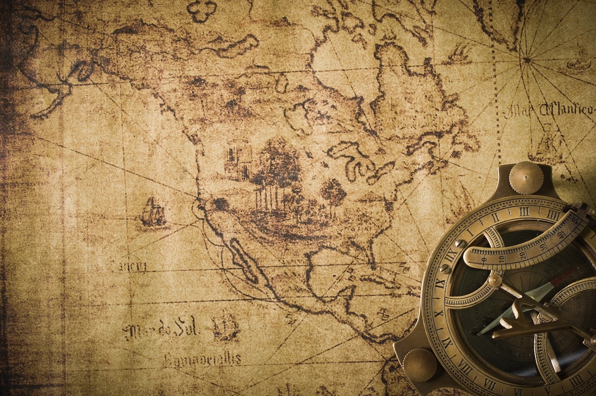
Lost in longitude or confused by contour lines? Want to know all the tips and tricks for getting the most out of your atlas? Curious if paper towns still exist? "Ask a Cartographer" is your opportunity to get the facts straight from the source. Tom Vitacco, Rand McNally Publishing’s Director of GIS, is here to answer your burning questions, and geek out over fascinating map lore – one exploration at a time.
This week, we are talking about some ways to figure out the inherent value of old Rand McNally maps and when they were made…
Question: "I have some old Rand McNally maps. Can you tell me the year they were made and the value of the maps?
Tom’s answer: Thank you for the question! This question, or a derivative of it, is one of the most asked questions we receive from customers. Unfortunately, I do not have any exact methodology to provide dates or values for older maps, and I always feel bad letting customers know that we have no way to truly answer this question. However, I will try to offer some insights and a few routes to explore in your quest to find the value of your old maps. Plus, I can highlight some valuable Rand McNally maps from our legacy with interesting historical context and also mention an exciting new product line we are working on at the moment which is related to our vintage maps.
The Year of the Old Map
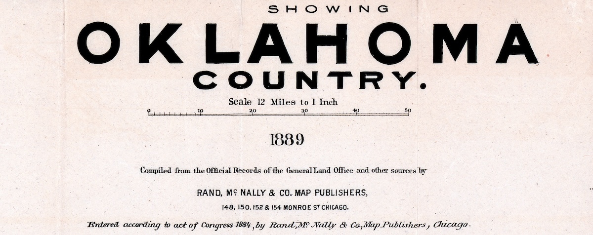
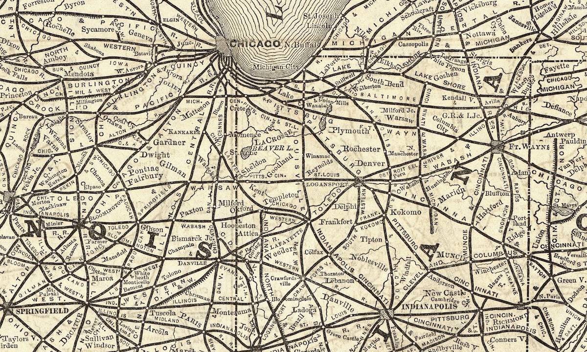
I mentioned above that I do not have any proven methods to date or value an old Rand McNally map and unfortunately I do not have access to an archive, ledger, or database which might store such information. In order to figure out when a map was made, the first recommendation I usually make is to check for a copyright date or year printed somewhere on the map, usually in a very small font near the map title or scale. Although the date might not be the exact year the map was created, it should be a fairly accurate representation of the date or time period it was made. The year 1889 shown in the example below is obvious but often the date or year is hard to find or non-existent on the map.
I have been with the company for 39 years now and while I have a good sense of the old map products and the cartographic styles used in the past, I would honestly just be guessing about the production date for an older map unless it was displayed on the map or I found it through an online search engine or website. I will usually tell customers to check the details on the map and if the year is not present, try to search on the specific map name and include “Rand McNally and Company” in the search as well and they might come across a site or online archive which lists the map with a date.
The Value of the Old Map
I am not an expert on how to value a map, but I will offer some suggestions based on what I have learned over the years. To me, determining the value of an old map is a combination of science and art. Generally, a map is worth whatever the market dictates…a simple, but accurate statement. A good starting point is to try to find out how much the map has sold for in the past by visiting auction sites, or high-end map retailers like Barry Lawrence Ruderman Antique Maps in California, or Geographicus Rare Antique Maps in New York. These sites usually offer original maps, not reproductions, and if you can find your map on one of these sites, you can get an idea of your map's worth based on the asking price since these sites often employ appraisers who know the value of older maps.
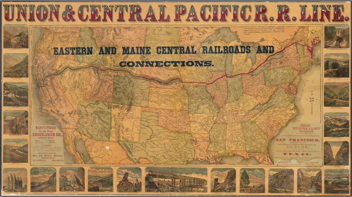
For example, the Union & Central Pacific Railroad Line map shown below, created by Rand McNally & Company in 1882, is currently retailing for $7,500 on the Barry Lawrence Ruderman site. This railroad map is extremely rare and emphasizes the Union and Central Pacific Railroad’s transcontinental route across the entire United States and parts of Canada. The map displays key rail corridors that improved travel from coast to coast, underscoring the growth and reach of American railroads during the late 19th century.
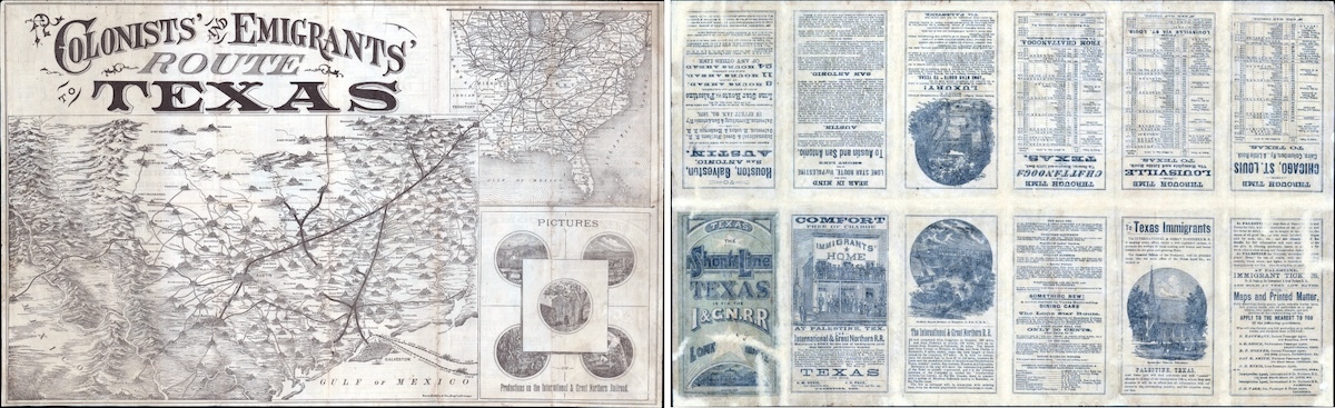
Another example of a rare and valuable old Rand McNally map can be found on the Geographicus site, entitled Colonists' and Emigrants' Route to Texas from 1877 (shown below). The map was mentioned in an earlier blog for the amazing details included within the map and the approach taken by the cartographers to create a map documenting the railroads and the efforts to promote “emigration” at the time by the state of Texas. This map retails for $3000.
The rarest Rand McNally maps, like the section of a map from an 1873 Railway Guide shown below, are often not for sale because they can only be found in institutional collections, such as those found in libraries or museums, while some map “variants” can sell for even higher amounts than the two examples above. I have heard the original 1924 “Road Atlas” titles in excellent condition have sold for tens of thousands of dollars, while other rare Rand McNally imprints have sold for similar amounts.
Putting value on an older map, especially rare maps, is often a challenge because there are a lot of variables to consider. You have to factor in age, color, condition, and rarity since each of these factors can affect value. Location, the individual cartographer who created the map, and historical significance can also play a role in the concept of value, so there are many things to consider when you try to value an older map. Physical condition might be the main consideration since tears, stains, or other types of damage can decrease the value. However, other influences may come into play like aesthetic appeal, since older maps are often displayed as decorations, or maps made by famous cartographers like Mercator or Blaeu usually have more intrinsic value than maps produced by lesser known cartographers or companies.
A couple of other resources to check on map prices are the Old Maps site, and the Rare Book Club, which both contain a lot of good information related to map values. Libraries often have great map collections as well, including the Newberry Library here in Chicago, which has a huge Rand McNally map collection. In general, large libraries can be an excellent resource to help value a map.
On a side note, since I just mentioned libraries, the Newberry Library is currently running a fascinating map exhibition called Mapping Outside the Lines with support from Rand McNally. The display is free and open to the public so if you are in Chicago please check it out if you get a chance.
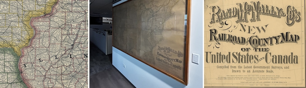
Finally, I wanted to share a photo of an old map we have hanging in our office since we are talking about the value of old maps in this blog. The framed map, called the New Railroad and County Map of the United States and Canada, is from 1876 and is very large as you can see below and very rare to find in one piece. The detail is incredible and while the map is slightly faded from the sun, we proudly display this vintage map in our space to honor the legacy of Rand McNally mapping!
Original Map versus Reproductions
One important concept related to value is whether the map is an original copy or a reproduction of the original map. I mentioned the two map dealers above for a reason - they only sell the original maps, which is why the prices are higher. So, if you purchase a map from a map dealer you are most likely buying the original map. Other sites like Etsy or online print shops like those found on Amazon are usually selling reproductions and not the original map which is why the price might be in the $30-$60 range. These resellers obtain a copy of the original map which was scanned or digitized and sell a print of the map on higher quality paper stock. There is nothing wrong with this approach and it ties into our new product I will discuss below, but it is important to understand the concept when discussing map value since original maps have a much higher value than a reproduction copy.
The Rand McNally Legacy Map Collection
I wanted to end this blog with a quick introduction to the new Legacy Map Collection we are working on and hope to launch soon. As I have mentioned in the past, Rand McNally donated most of the original maps we used to store in our company map library to the Newberry Library when we moved locations many years back. In fact, the Newberry Library has a large collection of original Rand McNally maps from all periods of company history.
With that said, we do not possess any original maps from our storied past outside of the large railroad map hanging on the wall in our office mentioned earlier. We do have access to images, however, through various libraries and digital collections and have decided to offer a selection of legacy map prints, or reproductions, at reasonable prices on our online store.
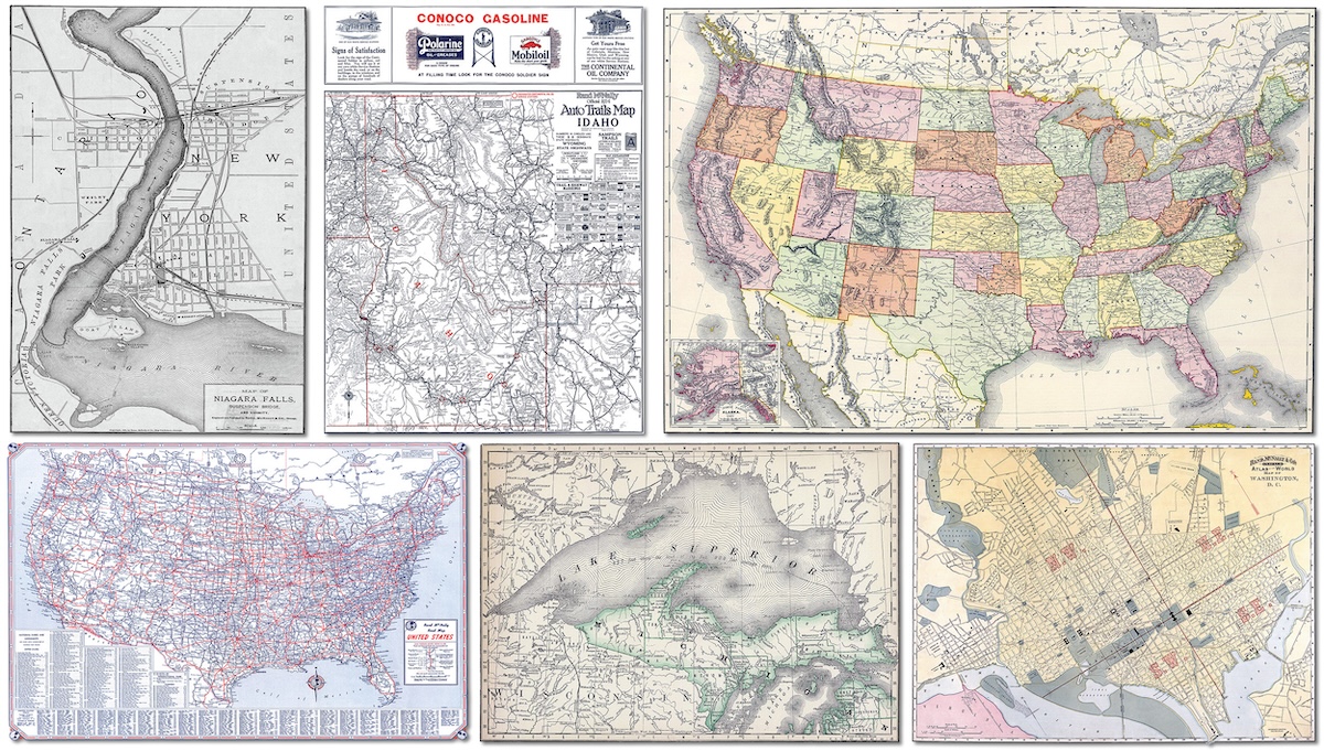
The maps will be representative of these four categories: city, state, railroad, and historic. Some examples are shown below. The plan is to offer a diverse set of older Rand McNally maps at standard frame sizes that customers could purchase and then matte and frame on their own. We are in the process of collecting and preparing maps for print and hope to have the online store up and running soon. If you ever wanted to display a legacy Rand McNally map, this will be your opportunity to buy one directly from the company who created these beautiful and historic maps.
Thanks again for the question! Hopefully, I was able to offer some insight on map values with this post. Feel free to submit your map or cartography questions below and check back soon for another installment of "Ask a Cartographer".
Have a question for our cartographer? Email us at printproducts@randpublishing.com with “Ask a Cartographer” in the subject line and your question could be featured next!