
Lost in longitude or confused by contour lines? Want to know all the tips and tricks for getting the most out of your atlas? Curious if paper towns still exist? "Ask a Cartographer" is your opportunity to get the facts straight from the source. Tom Vitacco, Rand McNally Publishing’s Director of GIS is here to answer your burning questions, and geek out over fascinating map lore – one exploration at a time.
This week, we are discussing the new fake atlas trend…
Question: In your last column, you mentioned fake and AI-generated atlases. Can you tell us more about them?
Tom’s answer: Thanks for the interesting question and you are correct! At the end of the last blog post, I did reference an unfortunate trend in the publishing industry that has recently become more prevalent within the map and atlas category. I call it the “fake atlas” and hopefully this post will explain how to spot them and why you should steer clear of these imposter atlases.
I will start with a statement about print mapping in general. There are only a handful of mapping companies around that still print a true road atlas. Obviously, Rand McNally Publishing is one of these companies, and we continue to make what I feel are the best Road Atlases, State Maps, Wall Maps, and Educational titles all from within our corporate headquarters in the Chicago area. A few other “large companies” with well-known names still produce atlases as well, and there are smaller cartographic shops scattered around the country that create more regional or outdoor-focused map titles.
From my perspective, these fake atlases are low-quality products made with minimal effort for quick profit that degrade the standard set by the high quality atlases still being produced today. As a long-time cartographer, I know firsthand the effort that goes into producing an accurate, informative, and up-to-date road atlas, created from teams of experienced GIS, design, marketing, finance, supply chain, and operational staff. With that in mind, I will do my best to explain how these fake atlases are created and what to watch for when you shop for a new road atlas.
1. Low-Effort, Low-Quality Publishing
In the previous blog, I mentioned low-content publishing, which generally refers to publications that contain minimal written content with many repetitive pages such as journals, planners, and sketchbooks. These books focus on design and organization, instead of a lot of composed or graphic material. This trend is often marketed as a way for new authors to make a name for themselves and create passive income. There are a ton of “get-rich quick” videos related to low-content publishing using Amazon tools and their marketplace to sell these books.
I personally feel these fake atlases fall more into the “low effort” rather than the “low content” category since I genuinely believe it takes minimal effort to create one of these so-called atlases.
As an example, say an “author” named John Smith decides to create their own fake 2025 Road Atlas under the John Smith Publishing company name. They would start by using any AI image creation tool to make the front cover by providing a descriptive prompt to allow the image generator to produce a suitable cover image. The image below was created in five minutes using Adobe Firefly.
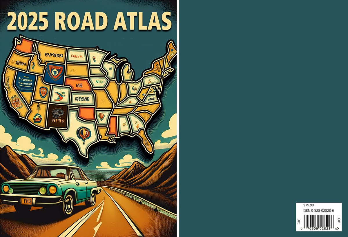
Granted, it is not particularly good, but I wanted to generate an example to show how easy it can be. You will notice the back cover is blank except for a bar code, which is often a tell-tale sign of a fake atlas. Most real publishing companies would use the back cover for advertising or promotion since it is valuable real estate on a printed product.
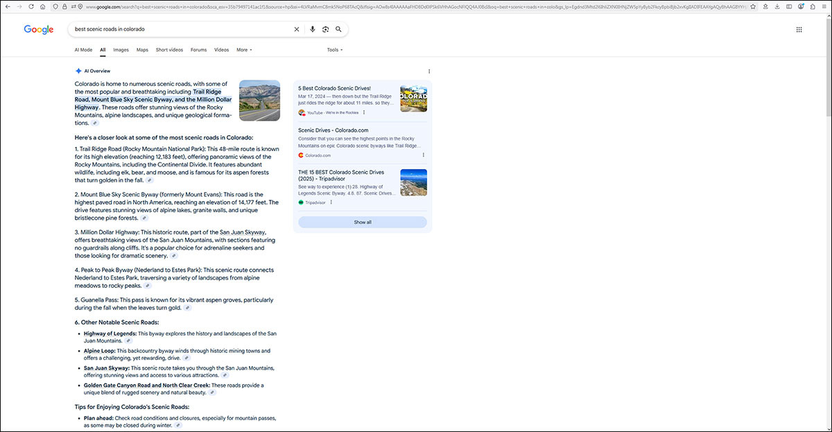
Next the author would search the web to get ideas and collect data and information for their fake atlas. Here is an example of the content returned when searching for the “best scenic roads in Colorado,” most of which is AI-generated. The author could search for “top campgrounds in Colorado” or “top getaways” or any travel related content. This content is captured into a Word doc (or any word processor), providing the author with a lot of travel or geographic information to use with little effort to produce. Personally, I do not support this type of content gathering and am not sure of the legalities related to using AI content generated from online searches, but I am guessing this is how a lot of content is generated for these atlases.
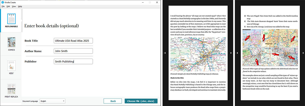
 After the atlas content is collected and organized, the author could download and install the Kindle Create app, which Amazon provides for free so anyone can produce an eBook to sell on Amazon. Once installed, the author can quickly import the Word doc or a PDF into Kindle Create in a few different formats like reflowable or print replica, then provide a Title, Author Name and Publisher and the software does the rest.
One thing I have noticed about all of these fake atlases is they use a personal name for the Author or Publisher (like John Smith) instead of a company name that you most likely would recognize. So always check the publisher or author when purchasing an atlas and be wary if you do not know the name or click the author link to find out more about them and their product library.
The image below shows part of the content from the previous blog post referenced earlier after importing the Word document into Kindle Create (see image below on the left). There is a preview function which displays how the final eBook would appear (see image below on the right). Again, I spent maybe half an hour doing this work in order to create some sample images for this blog which supports the “low effort” concept I cited above.
Once the content and images are formatted, the author will start selling it on Amazon. I have noticed many of these titles on Amazon over the last few months and their titles are extremely similar to Rand McNally Publishing titles. For example, US Large Scale Road Atlas 2025, United States Motor Carriers’ Road Atlas 2025–2026, and The Ultimate United States Road Atlas are some of the existing titles available now. If you were not paying attention, you might think these are Rand McNally atlases!
The product descriptions will use tag lines with key words or phrases like “trusted” or “journey” or “not all road atlases are created equal” – again remarkably close to the type of marketing slogans that Rand McNally has used for a long time. Plus, the descriptions often blatantly lie, stating lines like “What makes this atlas special? First off, the large-scale maps.” Funny how the reviews say there are no maps to be found in this “special atlas.” Not one map…yet the descriptions emphasize the quality of the maps…too bad they do not exist. From what I can tell, if these fake atlases do include a map, it is often an image downloaded from a government website, or just a link to a state DOT map online. I have even seen one of these atlases that claim to include maps and in reality their map is just a headline like Pacific Coast Highway with a QR code graphic under the title that links to a google map of the area. To me, this is deceiving and not very functional for the customer.
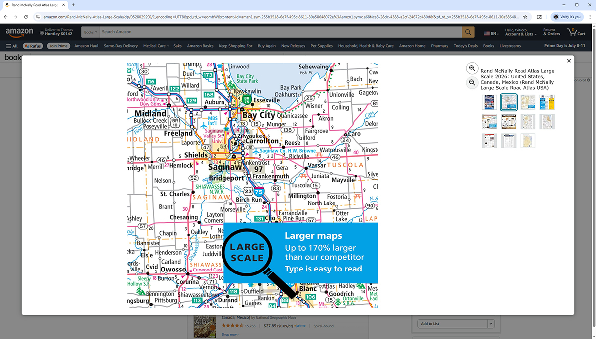 Rand McNally Publishing always includes product images that show the actual maps, plus the front cover and various pages from within the atlas (see example above from our 2026 Large Scale Road Atlas). Interestingly enough, I have noticed the fake atlases never show any thumbnail or “inside the product” images except the front and back cover, most likely because it would expose the lack of maps within the so-called atlas. When an atlas does not show the customer any map image from within the product, it should be a red flag to the customer to stay away.
In conclusion, I hope this post offers some insight into what is happening in the publishing world. Please keep an eye out for these authors who are releasing fake atlases. They might offer an atlas using a familiar name, hoping the customer will not return the product once they realize it is not a real atlas. The author probably gets a few initial sales, then creates a new company or author name, changes the cover and releases the same content, repeating the process in the hopes they can make some money off this publishing trend. So, when searching for a new Road Atlas, try to ensure you are purchasing from a reputable map company.
Finally, if you have bought a Rand McNally product in the past, thank you for your support!
Feel free to submit your map or cartography questions below and check back soon for another installment of "Ask a Cartographer".
Have a question for our cartographer? Email us at printproducts@randpublishing.com with “Ask a Cartographer” in the subject line and your question could be featured next!