
Lost in longitude or confused by contour lines? Want to know all the tips and tricks for getting the most out of your atlas? Curious if paper towns still exist? "Ask a Cartographer" is your opportunity to get the facts straight from the source. Tom Vitacco, Rand McNally Publishing’s Director of GIS is here to answer your burning questions, and geek out over fascinating map lore – one exploration at a time.
This week, we are discussing why we feel our Road Atlases are the best out there…
Question: What makes your atlases better than the competition?
Tom’s answer: Great question and very timely since the new 2026 Rand McNally Road Atlases are out now! I can definitely offer some compelling insights into why our Road Atlases are the best maps out there for travel planning, navigation, or as a backup to your GPS device. I will cover some of the major differences between our products and the competition (mainly the National Geographic Adventure Edition Road Atlas) in relation to cartography, design, content, and product selection, plus emphasize some of the “not so obvious” advantages our maps have over other maps.
Why Not All Maps Are Not Created Equal
I recall hearing the phrase “all maps are not created equal” when I first started as a Rand McNally cartographer in the late 1980s, and I honestly did not pay much attention to its meaning until later in my career. I believe our Road Atlas maps are the best available if you consider their intended purpose - a collection of accurate and easy to read reference maps that offer the “big picture” overview of each state, province, city or country.
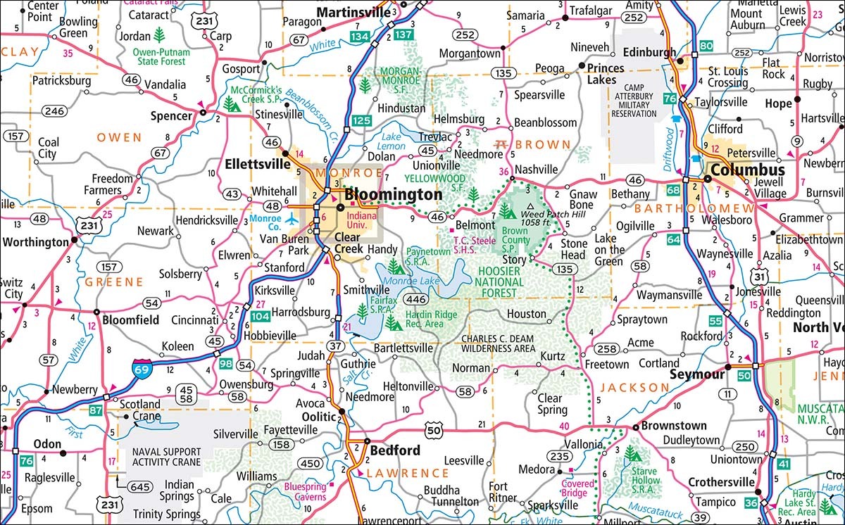
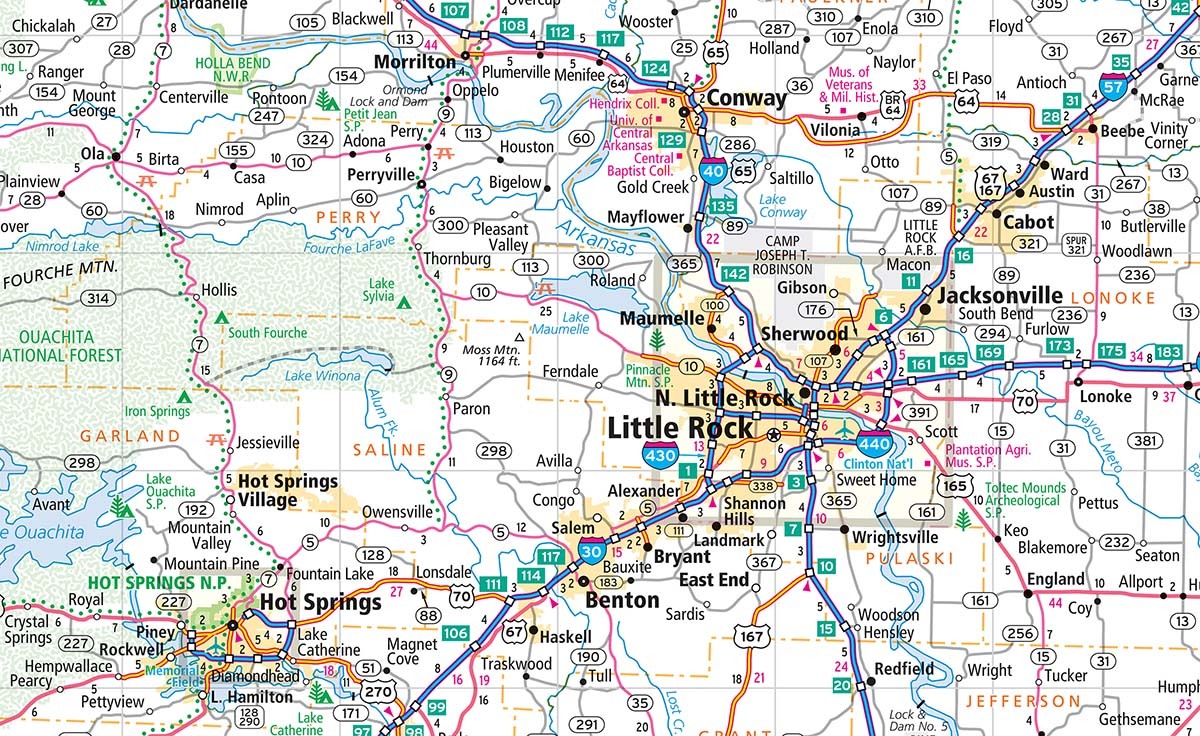 Pictured: Sample of a Rand McNally Publishing map of Arkansas.
1. Made in the USA by an In-House Cartography Team
Before we dive into the maps, I do feel it is important to mention that Rand McNally Publishing is based in the Chicago area, and the in-house cartographic team produces the Road Atlas maps from a proprietary database we built, developed and continue to maintain internally. In fact, all of the Road Atlas and State Map products are produced and printed in the United States. We do not outsource or use AI for the production of the Road Atlas maps or editorial content, which is why our products display a Rand McNally copyright (see image below) while competitor products often list other companies as the copyright holder. To me, this distinction directly correlates to why Rand McNally Publishing titles are known as the most trusted and accurate products to guide you on your journey.
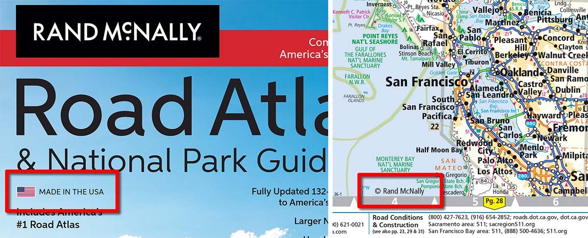
Pictured: Rand McNally Publishing products are made and printed in the USA.
2. High-Quality Cartography - We Update Every Year and Are Meticulous About Detail
Our Road Atlases are updated annually and each year the maps will include major updates such as the opening of Interstate 42 in North Carolina, or roads that have been widened or “twinned” (as they say in Canada), or major temporary changes like the bridge collapse in Baltimore. These major updates are all shown in the 2026 edition of the atlases. If you dig deeper though, the “minor details” included with our maps are what make our atlases stand out compared to other maps in the market.
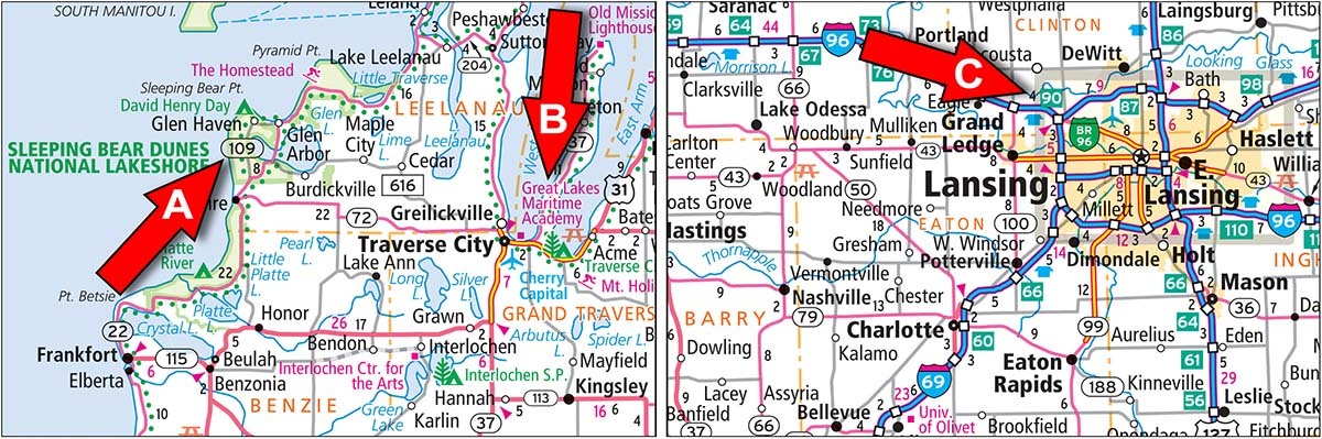
The image below contains some examples of road related map updates shown in our 2026 Road Atlas that are less obvious to the casual user. None of these updates are in the new edition of the competitor’s product mentioned earlier:
- State Route 67 was rerouted south of Granite Falls, Minnesota
- New mileage-based exit numbers along many routes in Connecticut
- State Route 440 designation was updated to I-440 northeast of Little Rock, Arkansas
- We removed the Rest Areas along I-65 in Indiana that were recently closed
- State Route 323 is shown as fully paved in Montana
- New Interchanges along US 218 in Iowa
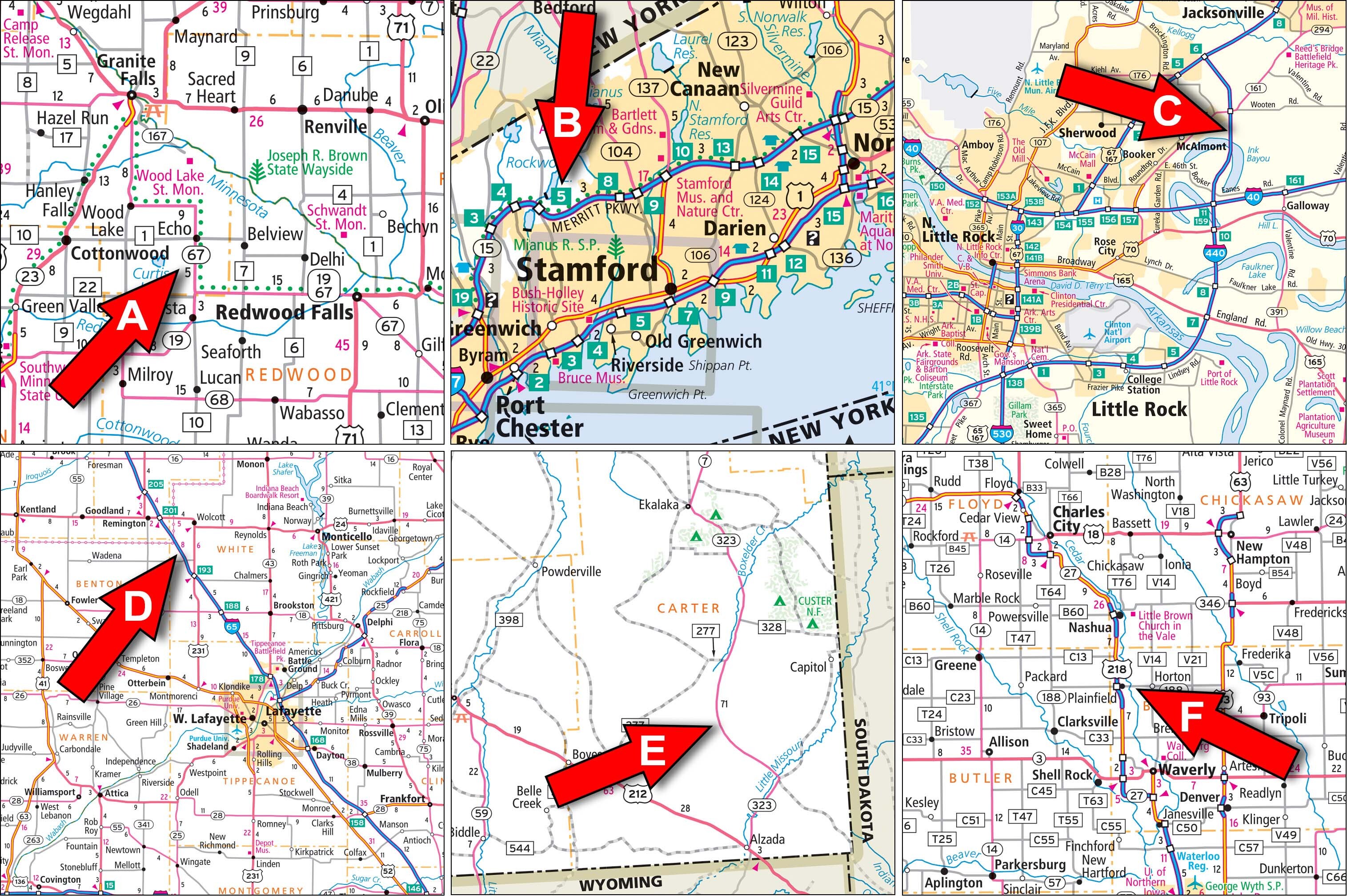
Pictured: Some road-related map updates added to the 2026 Road Atlas but not found in the competitor atlases.
Additionally, we focus on non-road updates as well, like points of interest, parks, streets or town related additions or changes. In the image below, you will see some examples of these types of map updates from the 2026 Road Atlas. Again, none of these updates are included in the new atlas from our main competitor:
- Cleveland Browns football stadium renamed to Huntington Bank Field
- New Route 66 Visitor Center added to the Albuquerque map
- Ventura Ave renamed to Cesar Chavez Blvd on the Fresno map
- The new Pisgah View State Park was added to the North Carolina map
- The Volo Auto Museum dropped “Auto” from their name northwest of Chicago
- New city of St. George, Louisiana was added to the map
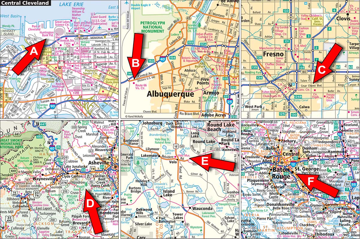
Pictured: Other types of map updates added to the 2026 Road Atlas but not found in the competitor atlases.
The examples above are just a small sampling of the types of “minor updates” we include in our atlas which are not found in their atlas. There are many more…in fact way too many to document here. Although seemingly minor, a rest area that has closed down but is still shown on the competitor map would be frustrating to say the least if you need a bathroom break while on the road.
For me as a cartographer, the “detailed changes” we make annually to our maps are a huge advantage over other maps in the market. Customers trust our maps…and we take pride in the quality of our products. As one customer recently said in their review on Amazon, “You can’t go wrong with a Rand McNally atlas!”
3. Our Map Design - The Most Clear, Concise and Easy to Use
Although map design is subjective, there are a few interesting techniques we employ to ensure our maps are legible compared to other maps. In terms of color, our maps continue to use the “primary color” scheme we have used for many years. The colors would not be considered “modern,” but they are effective which is why we still use them.
For example, in the image below you will notice our road hierarchy is quite easy to view at the state level. Limited access roads display in dark blue (or green for toll roads), divided highways are “orange,” major roads are a shade of red and minor roads are light gray. The major roads pop out on the map, while the minor roads fill in the background. You will notice subtle shades of green, gray and orange to symbolize parks, forests and other large areas of interest. The background of the map is white for clarity. In general, we feel our maps are clear, concise and easy to use because of the color palette we incorporate.
We also utilize subtle effects during the print process to help with readability on our maps. Three examples are shown on the image below:
- Highway shields knock out lines but not fills. In this example, the graphic for Hwy 109 does not show the gray road within the shield but it does show the blue water and green park tints which is known as variable masking. This subtle effect provides a much cleaner appearance to our map.
- Map labels that use a color similar to the linework underneath will use a “type halo” to ensure the label is easy to read. In this example, the red POI label would be hard to read on top of the red state highway line without the knockout.
- Overprinting is a standard printing technique, and we utilize this effect throughout our maps to help with design and clarity. The city inset locator box, shown in the tan color below, is set to overprint. It is layered on top of other map features, but you can still see those features through the tan color because the map feature is set to overprint which allows for transparency when appropriate.
While our map design might be considered traditional, it was purposely developed for ease of use, clarity and readability. I feel our design works better for the customer and is another advantage we offer compared to the competition.
4. Editorial Sections - We Give You More Fresh, Original Content
Another consideration when comparing our atlases to others is the content we provide beyond the maps, such as the editorial at the front of the different atlases or the information we provide along the margins of the map pages or even the quantity of maps included. I will quickly discuss each below.
First, our editorial section is conceptualized each year, then researched and designed to provide fresh, complimentary content to supplement the updated maps. We change the theme annually – for the 2026 atlases the subject was culinary road trips, but in the past has included scenic drives, festivals, and other travel related topics – and the pages feature new designs, photos, custom maps, and useful information. Our competition often just rehashes the same information with each edition, so little to no effort goes into the non-mapping section of their atlases.
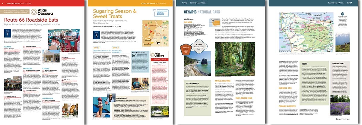
Pictured: Sample editorial pages from the 2026 Road Atlas product line.
Also, our atlases tend to be larger than the competition, both in physical size and page counts, since we strive to offer more content with each new edition. For example, the editorial section for the 2026 atlases grew from 6 to 16 pages compared to the 2025 editions, while page counts for other atlases have remained the same for years. Our design and marketing teams actively create new content for our customers while the competition seems to be content with using the same info year after year.
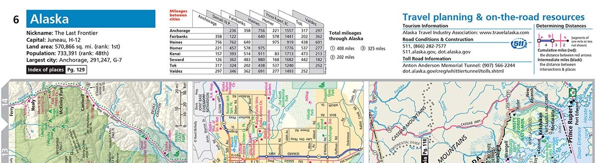
Our atlases have always provided useful travel content in the margin of the pages, including travel planning and road condition resources, distances between specific cities within each state, toll road information and even some state facts or figures. The content is consistent throughout the atlas and accessible while on the road.
Finally, Rand McNally atlases have more maps, specifically city maps, than the competition. Most modern road atlases will include all the states and provinces, along with a map of Mexico, and the differences are usually related to map scale or size, but we include more city maps than anyone else. Plus, our Road Atlas & National Park Guide has information and maps for all 63 National Parks while our competition only features 24 parks. Overall, our atlases just offer you more content on top of the most up-to-date maps available in print.
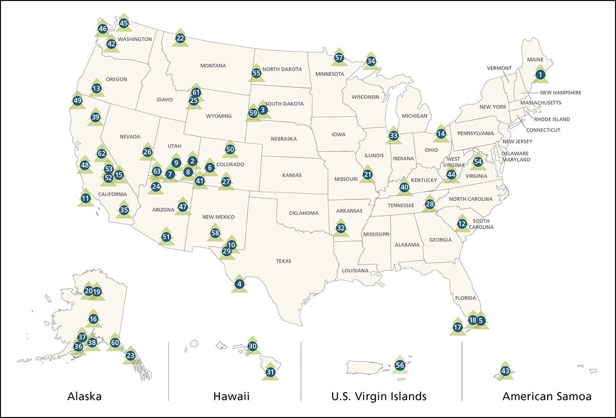
Pictured: Locator map showing all 63 National Parks included in the 2026 Road Atlas & National Park Guide.
5. A Better Product Selection - More Options for Every Kind of Journey
Rand McNally Publishing offers four versions of the Road Atlas each year, including three larger books and one smaller atlas that will fit comfortably in a vehicle. The base maps in the three larger atlases are the same (the Large Scale Road Atlas just enlarges the base maps for readability), while the map content is reduced in the smaller atlas to keep the maps legible. If you want more map content, the larger atlases are the way to go. If you prefer a smaller size for space reasons, then the Midsize Road Atlas is the better bet although the maps are not as detailed. In general, we offer more atlas options for our customers than our competition…period.

Pictured: From left to right, the 2026 Road Atlas, the Large Scale Road Atlas, the Road Atlas & National Park Guide and the Easy to Read Midsize Road Atlas.
6. No AI Used - A Word of Caution about Fake Atlases
One last point I wanted to bring up. AI is everywhere today, influencing many aspects of our daily lives, and is changing the way media is produced, including films, music, and art. The publishing industry has been affected as well, as “low content” self-published books are more prevalent on Amazon today than ever before. I recently noticed a new trend that I call the “fake atlas,” and I wanted to mention these imposters here.
These books are advertised using titles such as “the Ultimate United States Road Atlas” or “USA RV Road Atlas” when they honestly do not include any maps or might include one simple map of the US at the beginning along with a bunch of AI-generated travel information. They often include a cover image that looks AI-generated, and the back cover is almost always empty except for a bar code. The product descriptions will mention state maps, but if you read the reviews you will quickly find that there are no maps in these so-called atlases, so please be careful when searching for Road Atlases online to make sure it is a reputable map company from which you are buying.
Summary
Remember, all maps are not created equal. The teams here at Rand McNally Publishing focus on creating up-to-date maps and interesting editorial content for our customers annually, since we believe it is especially important to add value to each new edition of our products. Our competition appears to repurpose content produced by outsourced vendors to keep their product alive in the marketplace. The difference is noticeable in the quality of the products.
Finally, thank you for your support! We hope you find our Road Atlas products accurate, innovative and helpful on whatever journey you take.
Thanks again for the question! Please feel free to submit your map or cartography questions below and check back soon for another installment of "Ask a Cartographer".
Have a question for our cartographer? Email us at printproducts@randpublishing.com with “Ask a Cartographer” in the subject line and your question could be featured next.