
Lost in longitude or confused by contour lines? Want to know all the tips and tricks for getting the most out of your atlas? Curious if paper towns still exist? "Ask a Cartographer" is your opportunity to get the facts straight from the source. Tom Vitacco, Rand McNally Publishing’s Director of GIS, is here to answer your burning questions, and geek out over fascinating map lore – one exploration at a time.
This week, we are discussing the new Vintage Wall Map Collection which is coming soon…
Question: "The last blog mentioned the legacy map collection currently in development. Can you provide more details?”
Tom’s answer: Thank you for the question and for taking the time to read the last blog! You are correct, I did briefly mention a new product line called The Legacy Map Collection (now called Vintage Wall Map Collection) at the end of the previous blog which is linked here. With this post, I will go into much more detail on the collection and discuss some of the interesting maps we will feature plus talk a bit about some of my favorite maps we are highlighting from a cartographic or visual standpoint.
The Rand McNally Publishing Vintage Wall Map Collection
As I have mentioned before, Rand McNally began making maps a long time ago and some of the earlier maps are fascinating representations of the country at the time. I have been with the company for almost four decades and during that time I do not recall publishing or reproducing any of the older maps. In fact, I honestly did not know much about the old map titles until I started writing about them in the "Ask a Cartographer" blog or by reviewing some of the historical documents produced by Steve Wiertz, a Senior GIS Analyst here at Rand McNally Publishing.
Earlier this year, our team visited the Newberry Library in Chicago, which has one of the largest collections of old Rand McNally maps anywhere, to view some of the early map titles. After that visit, the team met to conceptualize some new product suggestions and the idea of printing a selection of old Rand McNally maps was a topic of discussion. Once a plan was figured out, we decided to offer a range of vintage wall map prints at reasonable prices on our online store. Some examples are shown in the image below.
The goal is to offer vintage map reproductions at standard sizes for framing at an affordable price while presenting a few unique titles that you will not find at the usual reproduction shops online.
With the initial launch of the Vintage Wall Map collection, we are focusing on categories such as city, state, railroad and historic maps. I will go into more detail about these categories below.
City Maps
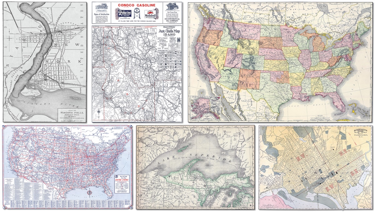
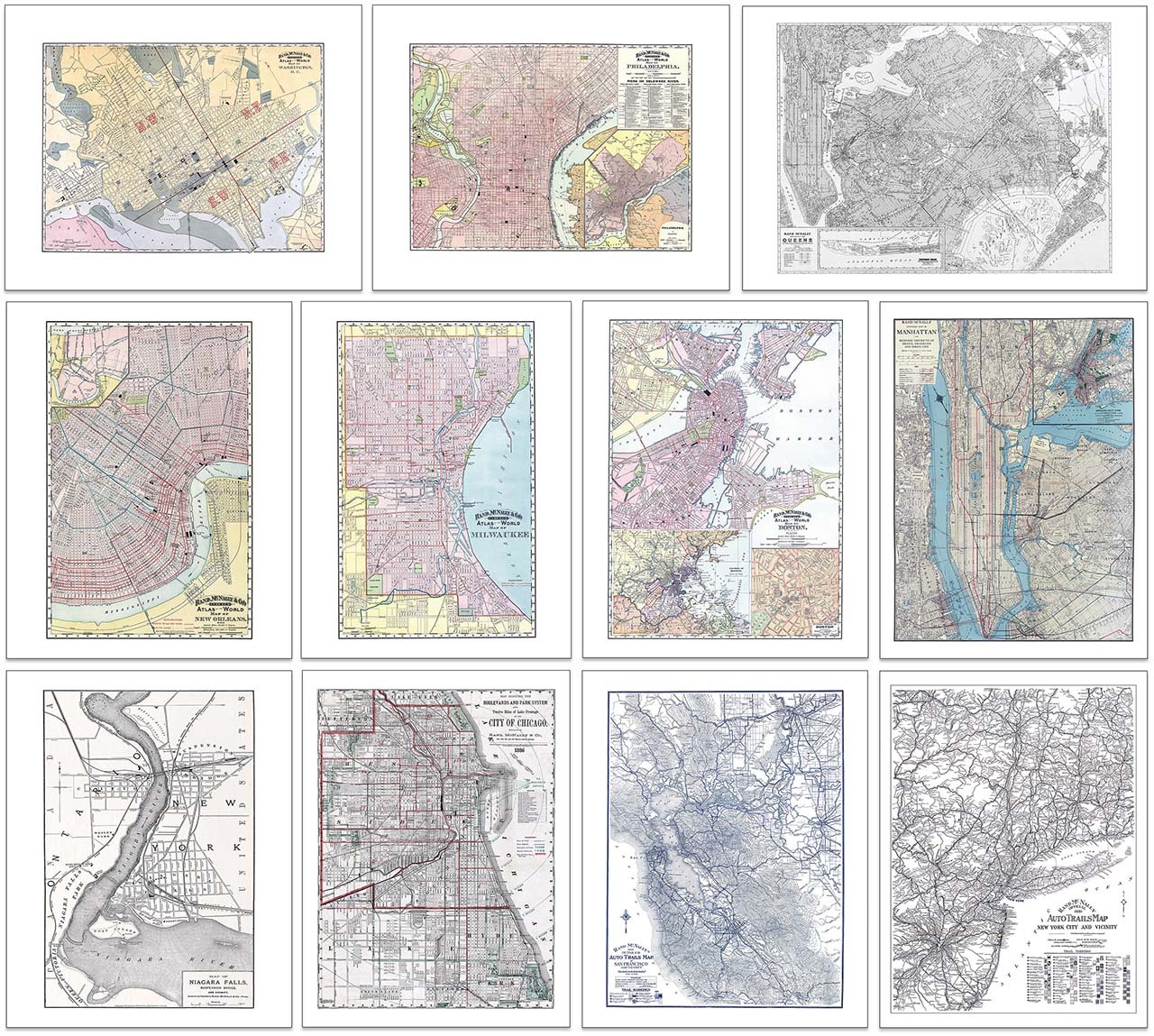
Rand McNally cartographers were creating maps of cities as early as the 1870s and our plan is to highlight a variety of these wonderful city maps with this product line. The initial batch of city maps will range from the 1880s to the 1920s and will focus on many different cities from across the country. The titles will include city maps from different Business Atlases produced in the late 1800s, plus a few maps created in the 1920s for the Auto Trails series of maps, and even a few maps produced for other companies at the time. Some examples of the city maps are shown in the image below.
One of my favorite maps from the city collection is the Niagara Falls map from 1885. There are a couple of reasons this map stands out to me. First, the cartography is very detailed for the time period as you can see in the cropped image below. The use of wavy lines in the water is unique, and I am sure it took a lot of skill and planning to create that effect with the available tools and techniques, plus the inclusion of various points of interest is fun to see. I did not know this map existed, so I am excited we were able to present it with this collection.
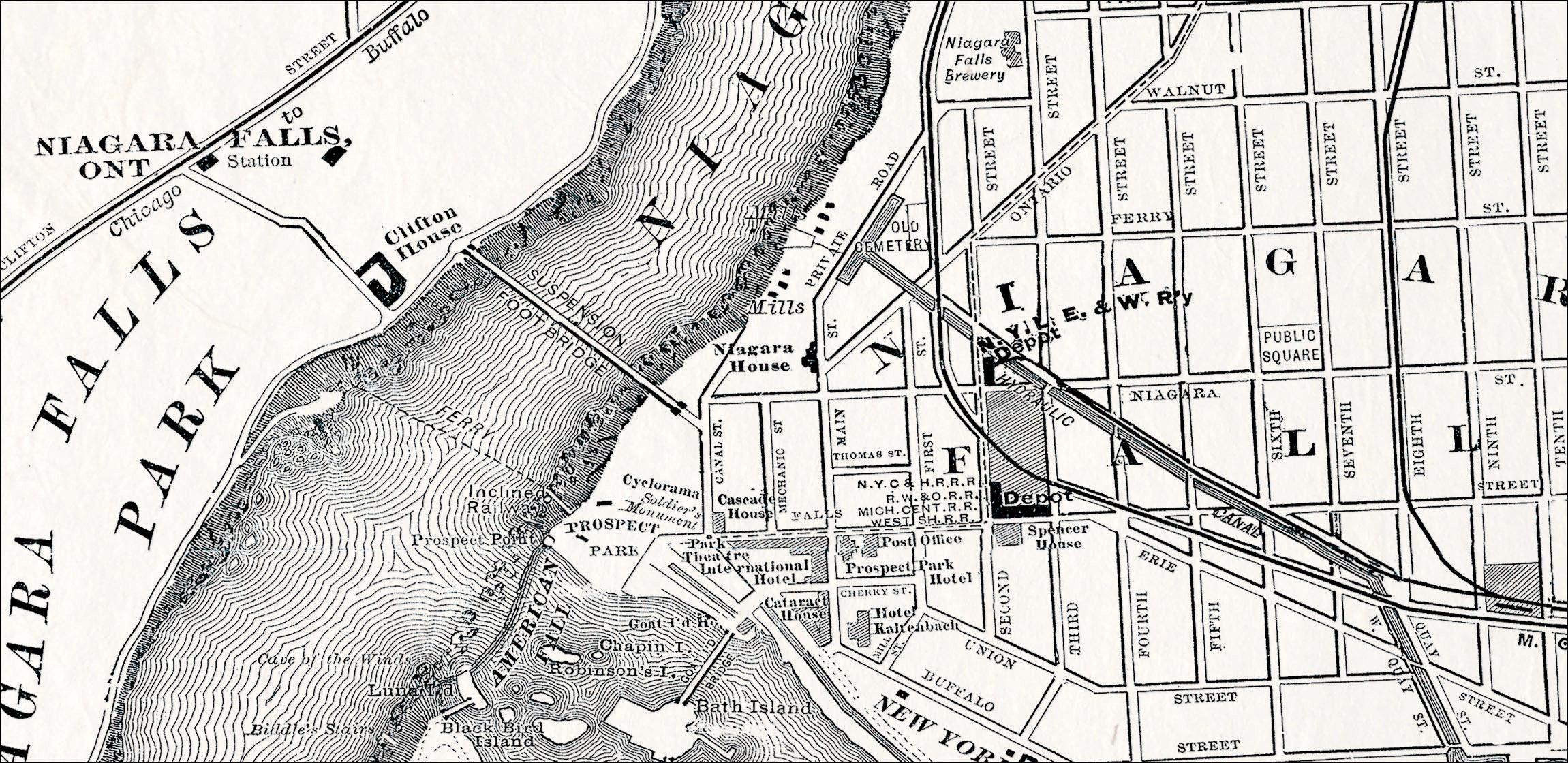
Another reason this map is one of my favorites is because I have fond memories of this area of New York. I have only visited the falls twice with my wife and daughters, and the trips were cherished times spent with family. Also, both my parents and in-laws went on their honeymoon to Niagara Falls as well and I recall hearing stories about it since they were there at the same time in the same year but did not know it at the time. So, the inclusion of this specific map is really special to me.
State Maps
State maps have been a Rand McNally tradition since the beginning, and we continue to produce up-to-date and accurate state maps to this day. For the Vintage Wall Map Collection, we have selected a few early state maps to launch the program with, but the plan is to offer many more in the near future.
The early maps will mainly come from the original Business Atlas or the Indexed Atlas of the World, which were both produced in the late 1800s. We will also feature some of the Auto Trails state maps from the 1920s, which I covered in this blog a couple of months back. You can see examples of the different state map styles in the image below.
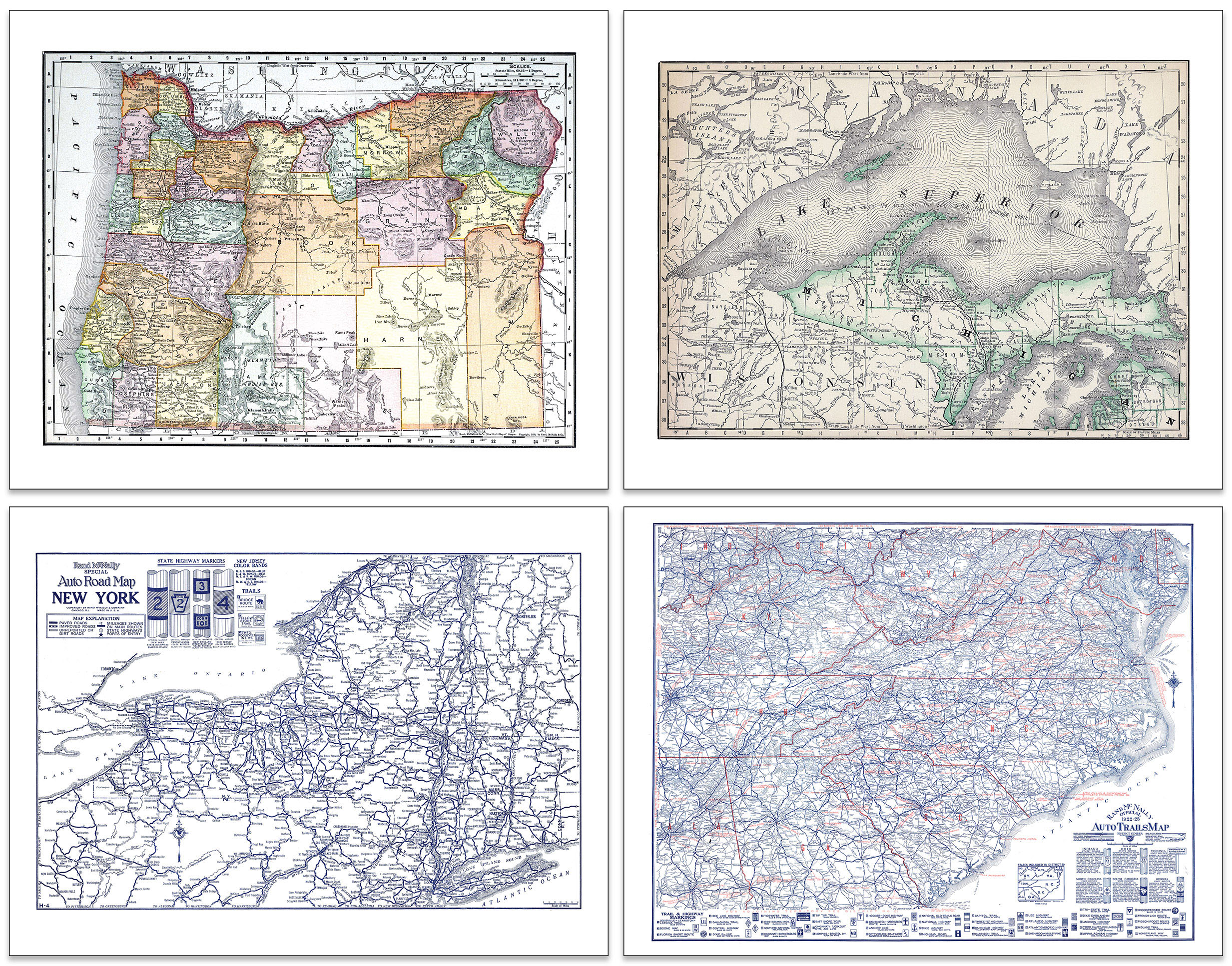
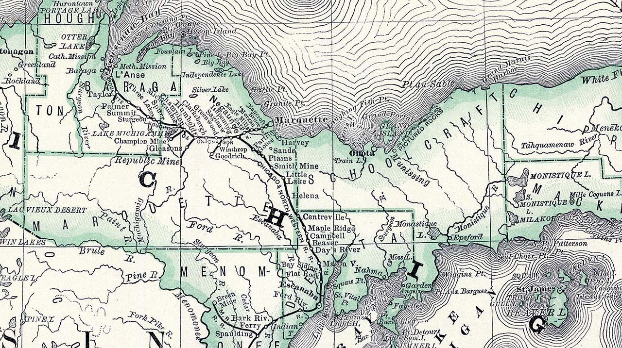
I really like the map of Northern Michigan in this collection (shown in the upper right corner of the image above), not only because of the fantastic presentation of this almost 150-year-old map, but also due to the fact that I love to travel to Michigan in general. My family and I visit Michigan annually in the summer since it is a short drive from our home in the suburbs of Chicago, so Michigan has a special place in my heart. The unique layout of the state is very interesting from a cartographic perspective, and I find the coverage of the Upper Peninsula and how the cartographers included all of Lake Superior fascinating within this map.
Similar to the Niagara Falls map mentioned earlier, the use of wavy lines in the water gives a sense of depth to the lake, and the display of railroad lines, towns and county boundaries show the importance of these features during the early days of transportation and commerce (see image below). Rand McNally cartographers were talented artists who were able to produce detailed maps highlighting important information for business and consumer travel, and as I look at these vintage maps their skill sets become even more apparent.
The Auto Trails state maps are also planned for The Vintage Wall Map Collection, and we will include a few to start with and hope to add more as we continue to build the collection. I have always found these maps to be very intriguing and innovative, since they were the precursor to the Road Atlas product line.
Railroad Maps
The very first maps that Rand McNally produced were focused on the railroad industry, so including these types of maps was important to this new collection. The company built its reputation on railroad maps, guides, tables, schedules, and tickets, and while we are only including a few railroad maps during the initial launch (see image below), we are considering other items like tickets, guides, and other memorabilia for the future.
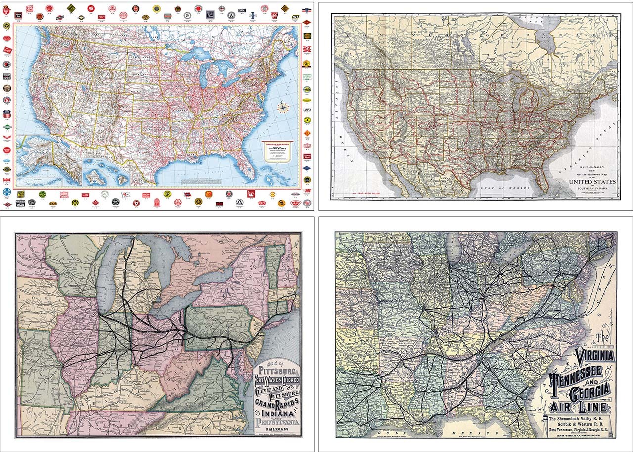
Some of the old railroad maps are extremely rare and hard to find, so we plan to start with a few maps from different eras including maps as old as 1874 (Pittsburgh, Fort Wayne and Chicago Railway map) and as recent as 1959 (American Railroads map). We tried to focus on maps that would print well and offered logos or well-known routes which might appeal to railroad enthusiasts or the general public alike.
Historic Maps
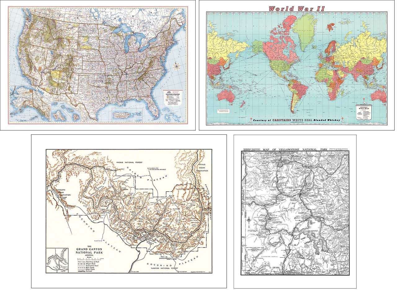
Finally, we will offer a few “historic” maps in this collection as well, which focus on topics such as recreation, military, and even a couple of early National Park maps of the Grand Canyon and Yellowstone (see image below). We felt these maps did not fall neatly into other categories but showcase the variety of maps the company produced during its long and storied history, so we decided to include them in the Historic Map category. These maps were developed between 1919 and 1966, so they are more modern than some of the other Vintage Wall Maps but offer distinct content that is exciting in their own right.
One of my favorite maps in the entire collection is the United States map shown below produced in 1893. The map is a combination of a political and physical map style, highlighting both state boundaries using various colors and hatched shaded relief to display terrain. The map includes railroads and cities as well as mountain ranges and hydrographic features. What strikes me the most about this map is the presentation in general. The colors, content, map projection, layout, and overall design stand out to me as an excellent example of the highly skilled cartographers that helped put Rand McNally “on the map” as they say back in the late 1800s.

Maps as Art or Decor
The United States map shown above is set to print at 36”x24” so it should fit many standard frames for hanging on the wall of a den, cabin or office. In fact, all of the maps should be easy to frame since we are using standard frame sizes for these reproduction prints. The images below are mocked up room photos to show the potential of adding these vintage maps in different settings.

We are currently adding The Vintage Wall Map Collection to our website and will let everyone know via our newsletter and our social channels (Facebook, Instagram and LinkedIn) when additional vintage map prints are available to purchase. If you have ever wanted to display a legacy Rand McNally map in your home or office, this will be your opportunity to buy one directly from the company who created these beautiful and historic maps!


Thanks again for the question! Feel free to submit your map or cartography questions below and check back soon for another installment of "Ask a Cartographer".
Have a question for our cartographer? Email us at printproducts@randpublishing.com with “Ask a Cartographer” in the subject line and your question could be featured next!